Horušice
Horušice | |
|---|---|
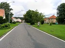 Centre of Horušice | |
 Flag  Coat of arms | |
 Horušice Location in the Czech Republic | |
| Coordinates: 49°59′48″N 15°25′44″E / 49.99667°N 15.42889°E | |
| Country | |
| Region | Central Bohemian |
| District | Kutná Hora |
| First mentioned | 1369 |
| Area | |
• Total | 8.48 km2 (3.27 sq mi) |
| Elevation | 228 m (748 ft) |
| Population (2025-01-01)[1] | |
• Total | 165 |
| • Density | 19/km2 (50/sq mi) |
| Time zone | UTC+1 (CET) |
| • Summer (DST) | UTC+2 (CEST) |
| Postal code | 285 73 |
| Website | obechorusice |
Horušice is a municipality and village in Kutná Hora District in the Central Bohemian Region of the Czech Republic. It has about 200 inhabitants.
Demographics
| Year | Pop. | ±% |
|---|---|---|
| 1869 | 430 | — |
| 1880 | 421 | −2.1% |
| 1890 | 432 | +2.6% |
| 1900 | 429 | −0.7% |
| 1910 | 453 | +5.6% |
| 1921 | 421 | −7.1% |
| 1930 | 397 | −5.7% |
| 1950 | 314 | −20.9% |
| 1961 | 317 | +1.0% |
| 1970 | 287 | −9.5% |
| 1980 | 244 | −15.0% |
| 1991 | 211 | −13.5% |
| 2001 | 187 | −11.4% |
| 2011 | 205 | +9.6% |
| 2021 | 179 | −12.7% |
| Source: Censuses[2][3] | ||
References
- ^ "Population of Municipalities – 1 January 2025". Czech Statistical Office. 2025-05-16.
- ^ "Historický lexikon obcí České republiky 1869–2011" (in Czech). Czech Statistical Office. 2015-12-21.
- ^ "Population Census 2021: Population by sex". Public Database. Czech Statistical Office. 2021-03-27.
External links
Wikimedia Commons has media related to Horušice.