Potěhy
Potěhy | |
|---|---|
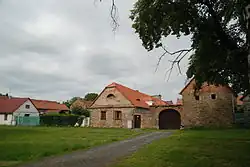 Centre of Potěhy | |
 Flag  Coat of arms | |
 Potěhy Location in the Czech Republic | |
| Coordinates: 49°52′10″N 15°25′13″E / 49.86944°N 15.42028°E | |
| Country | |
| Region | Central Bohemian |
| District | Kutná Hora |
| First mentioned | 1242 |
| Area | |
• Total | 4.99 km2 (1.93 sq mi) |
| Elevation | 294 m (965 ft) |
| Population (2025-01-01)[1] | |
• Total | 635 |
| • Density | 130/km2 (330/sq mi) |
| Time zone | UTC+1 (CET) |
| • Summer (DST) | UTC+2 (CEST) |
| Postal code | 285 63 |
| Website | www |
Potěhy is a municipality and village in Kutná Hora District in the Central Bohemian Region of the Czech Republic. It has about 600 inhabitants.
Demographics
| Year | Pop. | ±% |
|---|---|---|
| 1869 | 730 | — |
| 1880 | 761 | +4.2% |
| 1890 | 777 | +2.1% |
| 1900 | 869 | +11.8% |
| 1910 | 815 | −6.2% |
| 1921 | 840 | +3.1% |
| 1930 | 726 | −13.6% |
| 1950 | 529 | −27.1% |
| 1961 | 539 | +1.9% |
| 1970 | 498 | −7.6% |
| 1980 | 567 | +13.9% |
| 1991 | 543 | −4.2% |
| 2001 | 630 | +16.0% |
| 2011 | 609 | −3.3% |
| 2021 | 620 | +1.8% |
| Source: Censuses[2][3] | ||
References
- ^ "Population of Municipalities – 1 January 2025". Czech Statistical Office. 2025-05-16.
- ^ "Historický lexikon obcí České republiky 1869–2011" (in Czech). Czech Statistical Office. 2015-12-21.
- ^ "Population Census 2021: Population by sex". Public Database. Czech Statistical Office. 2021-03-27.
External links
Wikimedia Commons has media related to Potěhy.