Okřesaneč
Okřesaneč | |
|---|---|
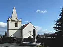 Church of Saint Bartholomew | |
 Okřesaneč Location in the Czech Republic | |
| Coordinates: 49°51′9″N 15°28′33″E / 49.85250°N 15.47583°E | |
| Country | |
| Region | Central Bohemian |
| District | Kutná Hora |
| First mentioned | 1352 |
| Area | |
• Total | 2.39 km2 (0.92 sq mi) |
| Elevation | 311 m (1,020 ft) |
| Population (2025-01-01)[1] | |
• Total | 213 |
| • Density | 89/km2 (230/sq mi) |
| Time zone | UTC+1 (CET) |
| • Summer (DST) | UTC+2 (CEST) |
| Postal code | 286 01 |
| Website | okresanec |
Okřesaneč is a municipality and village in Kutná Hora District in the Central Bohemian Region of the Czech Republic. It has about 200 inhabitants.
Demographics
| Year | Pop. | ±% |
|---|---|---|
| 1869 | 387 | — |
| 1880 | 409 | +5.7% |
| 1890 | 399 | −2.4% |
| 1900 | 391 | −2.0% |
| 1910 | 409 | +4.6% |
| 1921 | 424 | +3.7% |
| 1930 | 386 | −9.0% |
| 1950 | 346 | −10.4% |
| 1961 | 392 | +13.3% |
| 1970 | 346 | −11.7% |
| 1980 | 258 | −25.4% |
| 1991 | 207 | −19.8% |
| 2001 | 191 | −7.7% |
| 2011 | 189 | −1.0% |
| 2021 | 192 | +1.6% |
| Source: Censuses[2][3] | ||
References
- ^ "Population of Municipalities – 1 January 2025". Czech Statistical Office. 2025-05-16.
- ^ "Historický lexikon obcí České republiky 1869–2011" (in Czech). Czech Statistical Office. 2015-12-21.
- ^ "Population Census 2021: Population by sex". Public Database. Czech Statistical Office. 2021-03-27.
External links
Wikimedia Commons has media related to Okřesaneč.