Huštěnovice
Huštěnovice | |
|---|---|
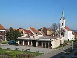 Municipal office and Church of Saint Anne | |
 Flag 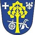 Coat of arms | |
 Huštěnovice Location in the Czech Republic | |
| Coordinates: 49°6′29″N 17°27′52″E / 49.10806°N 17.46444°E | |
| Country | |
| Region | Zlín |
| District | Uherské Hradiště |
| First mentioned | 1220 |
| Area | |
• Total | 6.60 km2 (2.55 sq mi) |
| Elevation | 186 m (610 ft) |
| Population (2025-01-01)[1] | |
• Total | 998 |
| • Density | 150/km2 (390/sq mi) |
| Time zone | UTC+1 (CET) |
| • Summer (DST) | UTC+2 (CEST) |
| Postal code | 687 03 |
| Website | www |
Huštěnovice is a municipality and village in Uherské Hradiště District in the Zlín Region of the Czech Republic. It has about 1,000 inhabitants.
Huštěnovice lies approximately 5 kilometres (3 mi) north of Uherské Hradiště, 21 km (13 mi) south-west of Zlín, and 246 km (153 mi) south-east of Prague.
Demographics
| Year | Pop. | ±% |
|---|---|---|
| 1869 | 833 | — |
| 1880 | 956 | +14.8% |
| 1890 | 909 | −4.9% |
| 1900 | 968 | +6.5% |
| 1910 | 936 | −3.3% |
| 1921 | 1,013 | +8.2% |
| 1930 | 1,093 | +7.9% |
| 1950 | 1,158 | +5.9% |
| 1961 | 1,254 | +8.3% |
| 1970 | 1,186 | −5.4% |
| 1980 | 1,068 | −9.9% |
| 1991 | 1,024 | −4.1% |
| 2001 | 1,002 | −2.1% |
| 2011 | 938 | −6.4% |
| 2021 | 945 | +0.7% |
| Source: Censuses[2][3] | ||
References
- ^ "Population of Municipalities – 1 January 2025". Czech Statistical Office. 2025-05-16.
- ^ "Historický lexikon obcí České republiky 1869–2011" (in Czech). Czech Statistical Office. 2015-12-21.
- ^ "Population Census 2021: Population by sex". Public Database. Czech Statistical Office. 2021-03-27.
External links
Wikimedia Commons has media related to Huštěnovice.