Korytná
Korytná | |
|---|---|
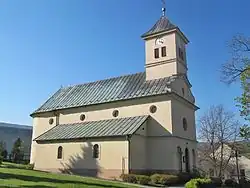 Church of Saint Wenceslaus | |
 Flag  Coat of arms | |
 Korytná Location in the Czech Republic | |
| Coordinates: 48°56′28″N 17°39′55″E / 48.94111°N 17.66528°E | |
| Country | |
| Region | Zlín |
| District | Uherské Hradiště |
| First mentioned | 1331 |
| Area | |
• Total | 12.75 km2 (4.92 sq mi) |
| Elevation | 340 m (1,120 ft) |
| Population (2025-01-01)[1] | |
• Total | 902 |
| • Density | 71/km2 (180/sq mi) |
| Time zone | UTC+1 (CET) |
| • Summer (DST) | UTC+2 (CEST) |
| Postal code | 687 52 |
| Website | www |
Korytná is a municipality and village in Uherské Hradiště District in the Zlín Region of the Czech Republic. It has about 900 inhabitants.
Korytná lies approximately 22 kilometres (14 mi) south-east of Uherské Hradiště, 33 km (21 mi) south of Zlín, and 268 km (167 mi) south-east of Prague.
Demographics
| Year | Pop. | ±% |
|---|---|---|
| 1869 | 532 | — |
| 1880 | 574 | +7.9% |
| 1890 | 642 | +11.8% |
| 1900 | 716 | +11.5% |
| 1910 | 983 | +37.3% |
| 1921 | 949 | −3.5% |
| 1930 | 939 | −1.1% |
| 1950 | 1,042 | +11.0% |
| 1961 | 1,236 | +18.6% |
| 1970 | 1,178 | −4.7% |
| 1980 | 1,182 | +0.3% |
| 1991 | 1,048 | −11.3% |
| 2001 | 987 | −5.8% |
| 2011 | 960 | −2.7% |
| 2021 | 899 | −6.4% |
| Source: Censuses[2][3] | ||
References
- ^ "Population of Municipalities – 1 January 2025". Czech Statistical Office. 2025-05-16.
- ^ "Historický lexikon obcí České republiky 1869–2011" (in Czech). Czech Statistical Office. 2015-12-21.
- ^ "Population Census 2021: Population by sex". Public Database. Czech Statistical Office. 2021-03-27.
External links
Wikimedia Commons has media related to Korytná.