Křtěnov
Křtěnov | |
|---|---|
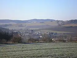 General view | |
 Flag  Coat of arms | |
 Křtěnov Location in the Czech Republic | |
| Coordinates: 49°32′42″N 16°25′9″E / 49.54500°N 16.41917°E | |
| Country | |
| Region | South Moravian |
| District | Blansko |
| First mentioned | 1447 |
| Area | |
• Total | 2.82 km2 (1.09 sq mi) |
| Elevation | 527 m (1,729 ft) |
| Population (2025-01-01)[1] | |
• Total | 207 |
| • Density | 73/km2 (190/sq mi) |
| Time zone | UTC+1 (CET) |
| • Summer (DST) | UTC+2 (CEST) |
| Postal code | 679 74 |
| Website | www |
Křtěnov is a municipality and village in Blansko District in the South Moravian Region of the Czech Republic. It has about 200 inhabitants.
Křtěnov lies approximately 26 kilometres (16 mi) north-west of Blansko, 41 km (25 mi) north of Brno, and 156 km (97 mi) south-east of Prague.
Demographics
| Year | Pop. | ±% |
|---|---|---|
| 1869 | 277 | — |
| 1880 | 288 | +4.0% |
| 1890 | 305 | +5.9% |
| 1900 | 299 | −2.0% |
| 1910 | 292 | −2.3% |
| 1921 | 308 | +5.5% |
| 1930 | 260 | −15.6% |
| 1950 | 218 | −16.2% |
| 1961 | 209 | −4.1% |
| 1970 | 217 | +3.8% |
| 1980 | 180 | −17.1% |
| 1991 | 205 | +13.9% |
| 2001 | 211 | +2.9% |
| 2011 | 225 | +6.6% |
| 2021 | 196 | −12.9% |
| Source: Censuses[2][3] | ||
References
- ^ "Population of Municipalities – 1 January 2025". Czech Statistical Office. 2025-05-16.
- ^ "Historický lexikon obcí České republiky 1869–2011" (in Czech). Czech Statistical Office. 2015-12-21.
- ^ "Population Census 2021: Population by sex". Public Database. Czech Statistical Office. 2021-03-27.
External links
Wikimedia Commons has media related to Křtěnov.