Libějice
Libějice | |
|---|---|
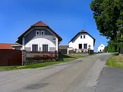 Centre of Libějice | |
 Flag  Coat of arms | |
 Libějice Location in the Czech Republic | |
| Coordinates: 49°22′37″N 14°37′26″E / 49.37694°N 14.62389°E | |
| Country | |
| Region | South Bohemian |
| District | Tábor |
| First mentioned | 1379 |
| Area | |
• Total | 2.95 km2 (1.14 sq mi) |
| Elevation | 490 m (1,610 ft) |
| Population (2025-01-01)[1] | |
• Total | 122 |
| • Density | 41/km2 (110/sq mi) |
| Time zone | UTC+1 (CET) |
| • Summer (DST) | UTC+2 (CEST) |
| Postal code | 390 02 |
| Website | www |
Libějice is a municipality and village in Tábor District in the South Bohemian Region of the Czech Republic. It has about 100 inhabitants.
Libějice lies approximately 6 kilometres (4 mi) south-west of Tábor, 46 km (29 mi) north of České Budějovice, and 81 km (50 mi) south of Prague.
Demographics
| Year | Pop. | ±% |
|---|---|---|
| 1869 | 164 | — |
| 1880 | 171 | +4.3% |
| 1890 | 173 | +1.2% |
| 1900 | 183 | +5.8% |
| 1910 | 154 | −15.8% |
| 1921 | 149 | −3.2% |
| 1930 | 160 | +7.4% |
| 1950 | 127 | −20.6% |
| 1961 | 126 | −0.8% |
| 1970 | 120 | −4.8% |
| 1980 | 110 | −8.3% |
| 1991 | 104 | −5.5% |
| 2001 | 109 | +4.8% |
| 2011 | 108 | −0.9% |
| 2021 | 118 | +9.3% |
| Source: Censuses[2][3] | ||
References
- ^ "Population of Municipalities – 1 January 2025". Czech Statistical Office. 2025-05-16.
- ^ "Historický lexikon obcí České republiky 1869–2011" (in Czech). Czech Statistical Office. 2015-12-21.
- ^ "Population Census 2021: Population by sex". Public Database. Czech Statistical Office. 2021-03-27.
External links
Wikimedia Commons has media related to Libějice.