Radimovice u Želče
Radimovice u Želče | |
|---|---|
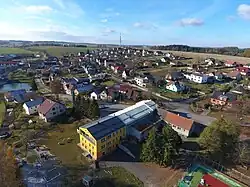 View from the southeast | |
 Flag  Coat of arms | |
 Radimovice u Želče Location in the Czech Republic | |
| Coordinates: 49°22′38″N 14°38′51″E / 49.37722°N 14.64750°E | |
| Country | |
| Region | South Bohemian |
| District | Tábor |
| First mentioned | 1307 |
| Area | |
• Total | 4.49 km2 (1.73 sq mi) |
| Elevation | 482 m (1,581 ft) |
| Population (2025-01-01)[1] | |
• Total | 444 |
| • Density | 99/km2 (260/sq mi) |
| Time zone | UTC+1 (CET) |
| • Summer (DST) | UTC+2 (CEST) |
| Postal code | 390 02 |
| Website | www |
Radimovice u Želče is a municipality and village in Tábor District in the South Bohemian Region of the Czech Republic. It has about 400 inhabitants.
Radimovice u Želče lies approximately 5 kilometres (3 mi) south of Tábor, 47 km (29 mi) north of České Budějovice, and 81 km (50 mi) south of Prague.
Demographics
| Year | Pop. | ±% |
|---|---|---|
| 1869 | 348 | — |
| 1880 | 368 | +5.7% |
| 1890 | 373 | +1.4% |
| 1900 | 369 | −1.1% |
| 1910 | 340 | −7.9% |
| 1921 | 311 | −8.5% |
| 1930 | 300 | −3.5% |
| 1950 | 257 | −14.3% |
| 1961 | 291 | +13.2% |
| 1970 | 256 | −12.0% |
| 1980 | 293 | +14.5% |
| 1991 | 313 | +6.8% |
| 2001 | 325 | +3.8% |
| 2011 | 389 | +19.7% |
| 2021 | 369 | −5.1% |
| Source: Censuses[2][3] | ||
References
- ^ "Population of Municipalities – 1 January 2025". Czech Statistical Office. 2025-05-16.
- ^ "Historický lexikon obcí České republiky 1869–2011" (in Czech). Czech Statistical Office. 2015-12-21.
- ^ "Population Census 2021: Population by sex". Public Database. Czech Statistical Office. 2021-03-27.
External links
Wikimedia Commons has media related to Radimovice u Želče.