Macaye
Macaye
Makea | |
|---|---|
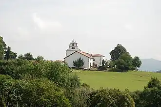 The church of Macaye | |
.svg.png) Coat of arms | |
Location of Macaye | |
 Macaye  Macaye | |
| Coordinates: 43°20′06″N 1°18′58″W / 43.335°N 1.3161°W | |
| Country | France |
| Region | Nouvelle-Aquitaine |
| Department | Pyrénées-Atlantiques |
| Arrondissement | Bayonne |
| Canton | Baïgura et Mondarrain |
| Intercommunality | Pays Basque |
| Government | |
| • Mayor (2020–2026) | Alain Dubois[1] |
Area 1 | 19.75 km2 (7.63 sq mi) |
| Population (2022)[2] | 594 |
| • Density | 30/km2 (78/sq mi) |
| Time zone | UTC+01:00 (CET) |
| • Summer (DST) | UTC+02:00 (CEST) |
| INSEE/Postal code | 64364 /64240 |
| Elevation | 113–892 m (371–2,927 ft) (avg. 218 m or 715 ft) |
| 1 French Land Register data, which excludes lakes, ponds, glaciers > 1 km2 (0.386 sq mi or 247 acres) and river estuaries. | |
Macaye (French pronunciation: [makaj]; Basque: Makea)[3] is a commune in the Pyrénées-Atlantiques department in south-western France.[4]
Population
| Year | Pop. | ±% p.a. |
|---|---|---|
| 1968 | 512 | — |
| 1975 | 468 | −1.28% |
| 1982 | 463 | −0.15% |
| 1990 | 476 | +0.35% |
| 1999 | 529 | +1.18% |
| 2007 | 534 | +0.12% |
| 2012 | 542 | +0.30% |
| 2017 | 587 | +1.61% |
| Source: INSEE[5] | ||
Geography
Neighboring communes
- Hasparren to the north
- Cambo-les-Bains to the north-west
- Mendionde to the east
- Louhossoa to the west
- Bidarray to the south
See also
References
- ^ "Répertoire national des élus: les maires". data.gouv.fr, Plateforme ouverte des données publiques françaises (in French). 2 December 2020.
- ^ "Populations de référence 2022" (in French). The National Institute of Statistics and Economic Studies. 19 December 2024.
- ^ MAKEA, Auñamendi Eusko Entziklopedia (in Spanish)
- ^ INSEE commune file
- ^ Population en historique depuis 1968, INSEE
Wikimedia Commons has media related to Macaye.
Municipalities in Labourd (Lapurdi) | ||
|---|---|---|
|  | |