Uhart-Mixe
Uhart-Mixe
Uharte-Hiri | |
|---|---|
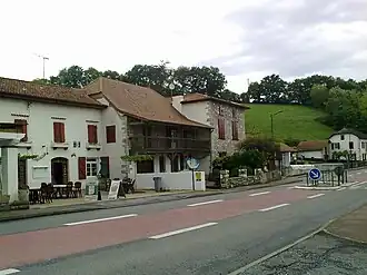 The village of Uhart-Mixe | |
.svg.png) Coat of arms | |
Location of Uhart-Mixe | |
 Uhart-Mixe  Uhart-Mixe | |
| Coordinates: 43°16′48″N 1°01′15″W / 43.28°N 1.0208°W | |
| Country | France |
| Region | Nouvelle-Aquitaine |
| Department | Pyrénées-Atlantiques |
| Arrondissement | Bayonne |
| Canton | Pays de Bidache, Amikuze et Ostibarre |
| Intercommunality | CA Pays Basque |
| Government | |
| • Mayor (2020–2026) | Bertrand Joseph Ithurbide[1] |
Area 1 | 11.74 km2 (4.53 sq mi) |
| Population (2022)[2] | 217 |
| • Density | 18/km2 (48/sq mi) |
| Time zone | UTC+01:00 (CET) |
| • Summer (DST) | UTC+02:00 (CEST) |
| INSEE/Postal code | 64539 /64120 |
| Elevation | 60–304 m (197–997 ft) (avg. 86 m or 282 ft) |
| 1 French Land Register data, which excludes lakes, ponds, glaciers > 1 km2 (0.386 sq mi or 247 acres) and river estuaries. | |
Uhart-Mixe (French pronunciation: [yaʁ miks]; Basque: Uhartehiri [uhaʁ̞tehiʁ̞i]) is a commune in the Pyrénées-Atlantiques department in south-western France.
It is located in the former province of Lower Navarre.[3]
See also
References
- ^ "Répertoire national des élus: les maires". data.gouv.fr, Plateforme ouverte des données publiques françaises (in French). 9 August 2021.
- ^ "Populations de référence 2022" (in French). The National Institute of Statistics and Economic Studies. 19 December 2024.
- ^ UHARTE-HIRI, Auñamendi Eusko Entziklopedia (in Spanish)
Wikimedia Commons has media related to Uhart-Mixe.