Namtit Subtownship
Namtit
Nang Teung • ဝဵင်းၼမ်ႉတိုၵ်း • 南邓 | |
|---|---|
.jpg) View of Namtit from Mengding Qingshuihe, China | |
 Namtit | |
| Coordinates: 23°28′0″N 98°51′0″E / 23.46667°N 98.85000°E | |
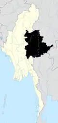
| Country | Myanmar (de jure) Wa State (Controlled by) |
| State | Shan State |
| Self-Administered Division | Wa |
| District | Hopang District |
| Township | Hopang Township |
| Elevation | 1,795 ft (547 m) |
| Time zone | UTC+6:30 (MMT) |
Namtit Subtownship (Parauk: Nang Teung;[2] simplified Chinese: 南邓; traditional Chinese: 南鄧; pinyin: Nán dèng) is a subtownship of the Wa Self-Administered Division of Shan State,[3] formerly and conterminously part of Hopang District. Its principal town is Namtit. It is de facto administrated as the Nang Teung Special District (simplified Chinese: 南邓特区; traditional Chinese: 南鄧特區; pinyin: Nán dèng tèqū; Wade–Giles: Nan-teng Tʻe-chʻü) of Wa State.
Rubber finishing factories were constructed in Mongmao and in Pangsang and in Namtit as well.[4]
References
- ^ GoogleEarth
- ^ Sing Tao Daily. "佤邦两高官涉电骗遭撤职" (in Chinese).
缅甸佤邦南邓欢迎您 Maung Man Hak Tiex Vax Veng :Nang Teung: Rieb Hoek Maix
- ^ Map of Shan State Archived 2012-03-14 at the Wayback Machine
- ^ "MRTV 3". Archived from the original on 2012-03-15. Retrieved 2014-09-01.