Poligny, Jura
Poligny | |
|---|---|
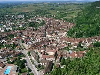 A general view of Poligny | |
 Flag .svg.png) Coat of arms | |
Location of Poligny | |
 Poligny  Poligny | |
| Coordinates: 46°50′12″N 5°42′31″E / 46.8367°N 5.7086°E | |
| Country | France |
| Region | Bourgogne-Franche-Comté |
| Department | Jura |
| Arrondissement | Dole |
| Canton | Poligny |
| Intercommunality | CC Arbois, Poligny, Salins - Coeur du Jura |
| Government | |
| • Mayor (2025–2026) | Dominique Bonnet[1] |
Area 1 | 51.48 km2 (19.88 sq mi) |
| Population (2022)[2] | 4,089 |
| • Density | 79/km2 (210/sq mi) |
| Time zone | UTC+01:00 (CET) |
| • Summer (DST) | UTC+02:00 (CEST) |
| INSEE/Postal code | 39434 /39800 |
| Elevation | 252–626 m (827–2,054 ft) |
| 1 French Land Register data, which excludes lakes, ponds, glaciers > 1 km2 (0.386 sq mi or 247 acres) and river estuaries. | |
Poligny (French pronunciation: [pɔliɲi] ⓘ) is a commune in the Jura department in Bourgogne-Franche-Comté in eastern France.[3]
The town stands at the foot of the first plateau of the Jura region, with limestone cliffs rising to its east and south, and a steephead valley leading to the village of Vaux-sur-Poligny to the east. On the cliffs to the east is a notable cave, known as "Le Trou de la Lune" (the Moonhole); on the cliffs to the south is a large cross, the "Croix du Dan". A network of hiking trails surrounds the town and provide routes to both these viewpoints, and the GR 59 long distance footpath runs through the town.
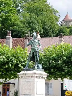
First Empire general Jean-Pierre Travot was born in Poligny; a statue in his honour stands in the principal square of the town, the Place des Déportés, and a road is named after him.
Poligny is served by the railway line from Besançon to Lons-le-Saunier.
The town is recognised as the "Capital of Comté", with a third of the region's production of this much-loved cheese being aged in the town's cellars. The town is also surrounded by vineyards, and is home to a number of independent wine producers as well as a cooperative. On 1 January 2025, the former commune of Vaux-sur-Poligny was merged into Poligny.[4]
Population
|
| ||||||||||||||||||||||||||||||||||||||||||||||||||||||||||||||||||||||||||||||||||||||||||||||||||||||||||||||||||
| Source: EHESS[5] and INSEE (1968-2017)[6] | |||||||||||||||||||||||||||||||||||||||||||||||||||||||||||||||||||||||||||||||||||||||||||||||||||||||||||||||||||
Gallery
-
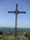 Croix du Dan
 -
-
_Church.jpg) Collégiale St.Hippolyte
Collégiale St.Hippolyte -
 Convent des Ursulines
 -
 Mouthier le Vieillard
 -
 Wladimir Gagneur
 -
 Tower of Paravis
 -
 Tower of the "Sergenterie"
 -

-
_Trou_de_la_Lune.jpg) Le Moon hole
Le Moon hole -
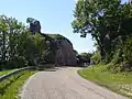 La "Roche Percée"
See also
References
- ^ "Répertoire national des élus: les maires" (in French). data.gouv.fr, Plateforme ouverte des données publiques françaises. 12 March 2025.
- ^ "Populations de référence 2022" (in French). The National Institute of Statistics and Economic Studies. 19 December 2024.
- ^ INSEE commune file
- ^ Arrêté du 4 décembre 2024 portant création de la commune nouvelle de Poligny, Légifrance, retrieved 15 January 2025
- ^ Des villages de Cassini aux communes d'aujourd'hui: Commune data sheet Poligny, EHESS (in French).
- ^ Population en historique depuis 1968, INSEE
External links
- . Encyclopædia Britannica (11th ed.). 1911.