Rouilly-Sacey
Rouilly-Sacey | |
|---|---|
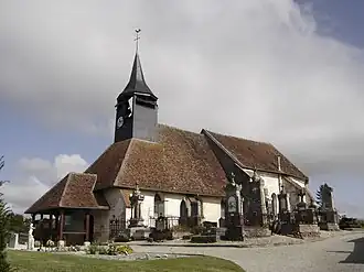 The church of Saint-Martin in Rouilly | |
Location of Rouilly-Sacey | |
 Rouilly-Sacey  Rouilly-Sacey | |
| Coordinates: 48°20′49″N 4°15′47″E / 48.3469°N 4.2631°E | |
| Country | France |
| Region | Grand Est |
| Department | Aube |
| Arrondissement | Troyes |
| Canton | Brienne-le-Château |
| Intercommunality | Forêts, lacs, terres en Champagne |
| Government | |
| • Mayor (2020–2026) | Patrick Dyon[1] |
Area 1 | 19.48 km2 (7.52 sq mi) |
| Population (2022)[2] | 388 |
| • Density | 20/km2 (52/sq mi) |
| Time zone | UTC+01:00 (CET) |
| • Summer (DST) | UTC+02:00 (CEST) |
| INSEE/Postal code | 10328 /10220 |
| Elevation | 113–188 m (371–617 ft) (avg. 118 m or 387 ft) |
| 1 French Land Register data, which excludes lakes, ponds, glaciers > 1 km2 (0.386 sq mi or 247 acres) and river estuaries. | |
Rouilly-Sacey (French pronunciation: [ʁuji sasɛ]) is a commune in the Aube department in north-central France.
Population
| Year | Pop. | ±% |
|---|---|---|
| 1962 | 243 | — |
| 1968 | 254 | +4.5% |
| 1975 | 296 | +16.5% |
| 1982 | 361 | +22.0% |
| 1990 | 342 | −5.3% |
| 1999 | 341 | −0.3% |
| 2008 | 328 | −3.8% |
See also
References
- ^ "Répertoire national des élus: les maires". data.gouv.fr, Plateforme ouverte des données publiques françaises (in French). 2 December 2020.
- ^ "Populations de référence 2022" (in French). The National Institute of Statistics and Economic Studies. 19 December 2024.
Wikimedia Commons has media related to Rouilly-Sacey.