Saint-Huruge
Saint-Huruge | |
|---|---|
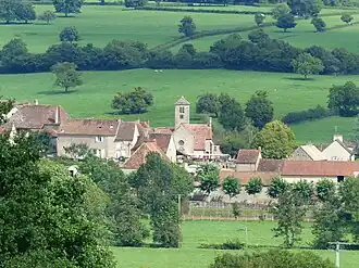 A general view of Saint-Huruge | |
 Coat of arms | |
Location of Saint-Huruge | |
 Saint-Huruge  Saint-Huruge | |
| Coordinates: 46°34′51″N 4°34′09″E / 46.5808°N 4.5692°E | |
| Country | France |
| Region | Bourgogne-Franche-Comté |
| Department | Saône-et-Loire |
| Arrondissement | Mâcon |
| Canton | Cluny |
| Government | |
| • Mayor (2020–2026) | Pierre Avenas[1] |
Area 1 | 4.03 km2 (1.56 sq mi) |
| Population (2022)[2] | 52 |
| • Density | 13/km2 (33/sq mi) |
| Time zone | UTC+01:00 (CET) |
| • Summer (DST) | UTC+02:00 (CEST) |
| INSEE/Postal code | 71427 /71460 |
| Elevation | 218–335 m (715–1,099 ft) (avg. 220 m or 720 ft) |
| 1 French Land Register data, which excludes lakes, ponds, glaciers > 1 km2 (0.386 sq mi or 247 acres) and river estuaries. | |
Saint-Huruge is a commune in the Saône-et-Loire department in the region of Bourgogne-Franche-Comté in eastern France.
See also
References
- ^ "Répertoire national des élus: les maires" (in French). data.gouv.fr, Plateforme ouverte des données publiques françaises. 13 September 2022.
- ^ "Populations de référence 2022" (in French). The National Institute of Statistics and Economic Studies. 19 December 2024.
Wikimedia Commons has media related to Saint-Huruge.