Vergisson
Vergisson | |
|---|---|
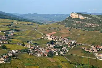 A general view of Vergisson | |
.svg.png) Coat of arms | |
Location of Vergisson | |
 Vergisson  Vergisson | |
| Coordinates: 46°18′32″N 4°42′55″E / 46.3088°N 4.71520°E | |
| Country | France |
| Region | Bourgogne-Franche-Comté |
| Department | Saône-et-Loire |
| Arrondissement | Mâcon |
| Canton | La Chapelle-de-Guinchay |
| Intercommunality | Mâconnais Beaujolais Agglomération |
Area 1 | 5.77 km2 (2.23 sq mi) |
| Population (2022)[1] | 233 |
| • Density | 40/km2 (100/sq mi) |
| Time zone | UTC+01:00 (CET) |
| • Summer (DST) | UTC+02:00 (CEST) |
| INSEE/Postal code | 71567 /71960 |
| Elevation | 255–575 m (837–1,886 ft) (avg. 320 m or 1,050 ft) |
| 1 French Land Register data, which excludes lakes, ponds, glaciers > 1 km2 (0.386 sq mi or 247 acres) and river estuaries. | |
Vergisson (French pronunciation: [vɛʁʒisɔ̃]) is a commune in the Saône-et-Loire department in the region of Bourgogne-Franche-Comté in eastern France.
Wine
The vineyards of Vergisson form part of the appellation d'origine contrôlée Pouilly-Fuissé.
Gallery
-
 View from Rock of Solutré.
 -
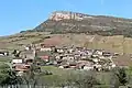
 View from Rock of Vergisson.
 -
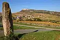
 View from Menhir de Chancerons.
 -
 Menhir de Chancerons.
 -
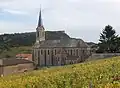
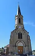 Église Saint-Martin.
 -
 Église Saint-Martin (view N).
 -
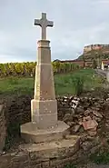 Wayside cross (1855).
See also
References
- ^ "Populations de référence 2022" (in French). The National Institute of Statistics and Economic Studies. 19 December 2024.
Wikimedia Commons has media related to Vergisson.