Saussemesnil
Saussemesnil | |
|---|---|
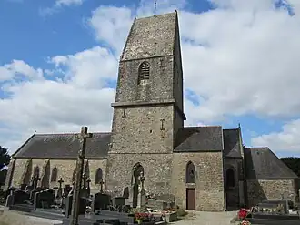 The church of Saint-Grégoire | |
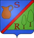 Coat of arms | |
Location of Saussemesnil | |
 Saussemesnil  Saussemesnil | |
| Coordinates: 49°34′15″N 1°28′57″W / 49.5708°N 1.4825°W | |
| Country | France |
| Region | Normandy |
| Department | Manche |
| Arrondissement | Cherbourg |
| Canton | Valognes |
| Intercommunality | CA Cotentin |
| Government | |
| • Mayor (2020–2026) | Jean-Marie Dorey[1] |
Area 1 | 21.45 km2 (8.28 sq mi) |
| Population (2022)[2] | 912 |
| • Density | 43/km2 (110/sq mi) |
| Time zone | UTC+01:00 (CET) |
| • Summer (DST) | UTC+02:00 (CEST) |
| INSEE/Postal code | 50567 /50700 |
| Elevation | 60–175 m (197–574 ft) |
| Website | www.sauxemesnil.fr |
| 1 French Land Register data, which excludes lakes, ponds, glaciers > 1 km2 (0.386 sq mi or 247 acres) and river estuaries. | |
Saussemesnil (French pronunciation: [sosmenil]) or Sauxemesnil or Sauxemesnil-Ruffosses[3] is a commune in the Manche department in Normandy in north-western France.
Heraldry
|
The arms of Saussemesnil are blazoned : Per bend sinister 1: Azure, a one handled pot proper and a capital letter S gules; 2: vert, 2 poplar trees eradicated proper, and to dexter the capital letter R gules, and a base azure; overall a bend sinister gules.
|
See also
References
- ^ "Répertoire national des élus: les maires" (in French). data.gouv.fr, Plateforme ouverte des données publiques françaises. 13 September 2022.
- ^ "Populations de référence 2022" (in French). The National Institute of Statistics and Economic Studies. 19 December 2024.
- ^ Name used by the official site of the commune
Wikimedia Commons has media related to Saussemesnil.