Sourdeval
Sourdeval | |
|---|---|
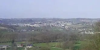 | |
Location of Sourdeval | |
 Sourdeval  Sourdeval | |
| Coordinates: 48°43′26″N 0°55′11″W / 48.7239°N 0.9197°W | |
| Country | France |
| Region | Normandy |
| Department | Manche |
| Arrondissement | Avranches |
| Canton | Le Mortainais |
| Intercommunality | CA Mont-Saint-Michel-Normandie |
| Government | |
| • Mayor (2023–2026) | Adrien Jehenne[1] |
Area 1 | 51.87 km2 (20.03 sq mi) |
| Population (2022)[2] | 3,040 |
| • Density | 59/km2 (150/sq mi) |
| Demonym | Sourdevalais |
| Time zone | UTC+01:00 (CET) |
| • Summer (DST) | UTC+02:00 (CEST) |
| INSEE/Postal code | 50582 /50150 |
| Elevation | 155–354 m (509–1,161 ft) (avg. 220 m or 720 ft) |
| Website | sourdeval.fr |
| 1 French Land Register data, which excludes lakes, ponds, glaciers > 1 km2 (0.386 sq mi or 247 acres) and river estuaries. | |
Sourdeval (French pronunciation: [suʁdəval]) is a commune in the Manche department in Normandy in north-western France. On 1 January 2016, the former commune of Vengeons was merged into Sourdeval.[3]
Population
| Year | Pop. | ±% p.a. |
|---|---|---|
| 1968 | 4,155 | — |
| 1975 | 4,234 | +0.27% |
| 1982 | 4,154 | −0.27% |
| 1990 | 3,763 | −1.23% |
| 1999 | 3,556 | −0.63% |
| 2007 | 3,378 | −0.64% |
| 2012 | 3,151 | −1.38% |
| 2017 | 3,173 | +0.14% |
| Source: INSEE[4] | ||
Heraldry
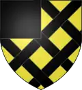 |
The arms of Sourdeval are blazoned : Or fretty sable, a canton of the second.
|
Twin towns
It is twinned with Odiham, a village in Hampshire.
See also
References
- ^ "Répertoire national des élus: les maires" (in French). data.gouv.fr, Plateforme ouverte des données publiques françaises. 16 April 2024.
- ^ "Populations de référence 2022" (in French). The National Institute of Statistics and Economic Studies. 19 December 2024.
- ^ Arrêté préfectoral 22/31 December 2015 (in French)
- ^ Population en historique depuis 1968, INSEE
Wikimedia Commons has media related to Sourdeval.