Sottevast
Sottevast | |
|---|---|
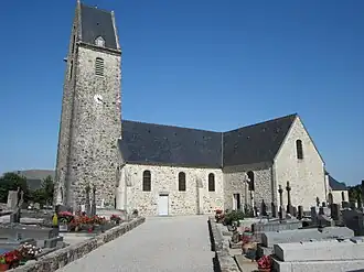 The church of Saint-Hermeland | |
Location of Sottevast | |
 Sottevast  Sottevast | |
| Coordinates: 49°31′25″N 1°35′35″W / 49.5236°N 1.5931°W | |
| Country | France |
| Region | Normandy |
| Department | Manche |
| Arrondissement | Cherbourg |
| Canton | Bricquebec-en-Cotentin |
| Intercommunality | CA Cotentin |
| Government | |
| • Mayor (2020–2026) | Jean-Pierre Tollemer[1] |
Area 1 | 10.82 km2 (4.18 sq mi) |
| Population (2022)[2] | 1,455 |
| • Density | 130/km2 (350/sq mi) |
| Time zone | UTC+01:00 (CET) |
| • Summer (DST) | UTC+02:00 (CEST) |
| INSEE/Postal code | 50579 /50260 |
| Elevation | 46 m (151 ft) |
| 1 French Land Register data, which excludes lakes, ponds, glaciers > 1 km2 (0.386 sq mi or 247 acres) and river estuaries. | |
Sottevast (French pronunciation: [sɔtva]) is a commune in Normandy in north-western France.
| Sottevast | |
|---|---|
| Part of Nazi Germany | |
| France | |
| Site information | |
| Type | bunker |
| Location | |
| Coordinates | 49°33′0.54″N 1°35′35.15″W / 49.5501500°N 1.5930972°W |
| Site history | |
| In use | captured before being used |
| Battles/wars | Operation Crossbow |
Sottevast in World War II
During World War II, there was a German storage and servicing bunker for V-weapons near Sottevast.[3] The site was captured by the 504th Parachute Infantry Regiment of the 82nd Airborne Division during the Normandy campaign.
References
- ^ "Répertoire national des élus: les maires". data.gouv.fr, Plateforme ouverte des données publiques françaises (in French). 2 December 2020.
- ^ "Populations de référence 2022" (in French). The National Institute of Statistics and Economic Studies. 19 December 2024.
- ^ "Sottevast V2 Facility". www.atlantikwall.org.uk. Hand Maid Tours. Retrieved 25 January 2017.
Wikimedia Commons has media related to Sottevast.