Zaritap Community
Zaritap
Զառիթափ | |
|---|---|
 | |
| Coordinates: 39°37′N 45°30′E / 39.617°N 45.500°E | |
| Country | Armenia |
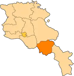
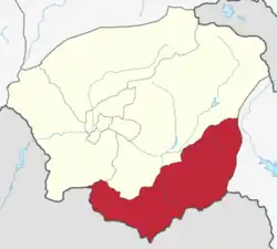
| Province | Vayots Dzor |
| Formed | 17 June 2016 |
| Administrative centre | Zaritap |
| Government | |
| • Mayor | Simon Babayan |
| Area | |
• Total | 468 km2 (181 sq mi) |
| Population (2011 census) | |
• Total | 3,906 |
| • Density | 8.3/km2 (22/sq mi) |
| Time zone | AMT (UTC+04) |
| Postal code | 3601–3810 |
| ISO 3166 code | AM-VD |
| FIPS 10-4 | AM10 |
| Website | www |
Zaritap Community (Armenian: Զառիթափ Համայնք Zaritap Hamaynk) is a rural community (municipality) and administrative subdivision of Vayots Dzor Province in southeastern Armenia, consisting of a group of villages whose administrative centre is at Zaritap.[1]
Villages
| Settlement | Type | Population (2011 census)[2] |
|---|---|---|
| Zaritap | Village, administrative centre | 1,380 |
| Artavan | Village | 321 |
| Bardzruni | Village | 361 |
| Gomk | Village | 139 |
| Kapuyt | Village | 23 |
| Khndzorut | Village | 500 |
| Martiros | Village | 601 |
| Nor Aznaberd | Village | 126 |
| Saravan | Village | 245 |
| Sers | Village | 189 |
| Ughedzor | Village | 21 |
| Akhta | Abandoned village | 0 |
| Horadis | Abandoned village | 0 |