Čermná (Trutnov District)
Čermná | |
|---|---|
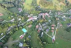 Aerial view | |
 Flag  Coat of arms | |
 Čermná Location in the Czech Republic | |
| Coordinates: 50°33′0″N 15°46′11″E / 50.55000°N 15.76972°E | |
| Country | |
| Region | Hradec Králové |
| District | Trutnov |
| First mentioned | 1362 |
| Area | |
• Total | 9.32 km2 (3.60 sq mi) |
| Elevation | 387 m (1,270 ft) |
| Population (2025-01-01)[1] | |
• Total | 417 |
| • Density | 45/km2 (120/sq mi) |
| Time zone | UTC+1 (CET) |
| • Summer (DST) | UTC+2 (CEST) |
| Postal code | 543 77 |
| Website | www |
Čermná is a municipality and village in Trutnov District in the Hradec Králové Region of the Czech Republic. It has about 400 inhabitants.
Demographics
| Year | Pop. | ±% |
|---|---|---|
| 1869 | 1,108 | — |
| 1880 | 1,100 | −0.7% |
| 1890 | 1,080 | −1.8% |
| 1900 | 1,089 | +0.8% |
| 1910 | 1,119 | +2.8% |
| 1921 | 1,001 | −10.5% |
| 1930 | 1,038 | +3.7% |
| 1950 | 632 | −39.1% |
| 1961 | 580 | −8.2% |
| 1970 | 453 | −21.9% |
| 1980 | 414 | −8.6% |
| 1991 | 357 | −13.8% |
| 2001 | 370 | +3.6% |
| 2011 | 376 | +1.6% |
| 2021 | 397 | +5.6% |
| Source: Censuses[2][3] | ||
References
- ^ "Population of Municipalities – 1 January 2025". Czech Statistical Office. 2025-05-16.
- ^ "Historický lexikon obcí České republiky 1869–2011" (in Czech). Czech Statistical Office. 2015-12-21.
- ^ "Population Census 2021: Population by sex". Public Database. Czech Statistical Office. 2021-03-27.
External links
Wikimedia Commons has media related to Čermná (Trutnov District).