Dolní Branná
Dolní Branná | |
|---|---|
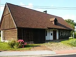 House No. 84, a typical log house | |
 Flag  Coat of arms | |
 Dolní Branná Location in the Czech Republic | |
| Coordinates: 50°35′40″N 15°35′32″E / 50.59444°N 15.59222°E | |
| Country | |
| Region | Hradec Králové |
| District | Trutnov |
| First mentioned | 1357 |
| Area | |
• Total | 7.91 km2 (3.05 sq mi) |
| Elevation | 428 m (1,404 ft) |
| Population (2025-01-01)[1] | |
• Total | 1,031 |
| • Density | 130/km2 (340/sq mi) |
| Time zone | UTC+1 (CET) |
| • Summer (DST) | UTC+2 (CEST) |
| Postal code | 543 62 |
| Website | www |
Dolní Branná is a municipality and village in Trutnov District in the Hradec Králové Region of the Czech Republic. It has about 1,000 inhabitants.
Demographics
| Year | Pop. | ±% |
|---|---|---|
| 1869 | 1,375 | — |
| 1880 | 1,328 | −3.4% |
| 1890 | 1,348 | +1.5% |
| 1900 | 1,397 | +3.6% |
| 1910 | 1,402 | +0.4% |
| 1921 | 1,293 | −7.8% |
| 1930 | 1,294 | +0.1% |
| 1950 | 972 | −24.9% |
| 1961 | 1,001 | +3.0% |
| 1970 | 968 | −3.3% |
| 1980 | 875 | −9.6% |
| 1991 | 852 | −2.6% |
| 2001 | 901 | +5.8% |
| 2011 | 942 | +4.6% |
| 2021 | 949 | +0.7% |
| Source: Censuses[2][3] | ||
References
- ^ "Population of Municipalities – 1 January 2025". Czech Statistical Office. 2025-05-16.
- ^ "Historický lexikon obcí České republiky 1869–2011" (in Czech). Czech Statistical Office. 2015-12-21.
- ^ "Population Census 2021: Population by sex". Public Database. Czech Statistical Office. 2021-03-27.
External links
Wikimedia Commons has media related to Dolní Branná.