Dolní Lánov
Dolní Lánov | |
|---|---|
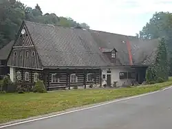 A typical log house | |
 Flag  Coat of arms | |
 Dolní Lánov Location in the Czech Republic | |
| Coordinates: 50°35′13″N 15°39′52″E / 50.58694°N 15.66444°E | |
| Country | |
| Region | Hradec Králové |
| District | Trutnov |
| First mentioned | 1359 |
| Area | |
• Total | 15.77 km2 (6.09 sq mi) |
| Elevation | 426 m (1,398 ft) |
| Population (2025-01-01)[1] | |
• Total | 824 |
| • Density | 52/km2 (140/sq mi) |
| Time zone | UTC+1 (CET) |
| • Summer (DST) | UTC+2 (CEST) |
| Postal code | 543 41 |
| Website | www |
Dolní Lánov (German: Nieder Langenau) is a municipality and village in Trutnov District in the Hradec Králové Region of the Czech Republic. It has about 800 inhabitants.
Demographics
| Year | Pop. | ±% |
|---|---|---|
| 1869 | 1,796 | — |
| 1880 | 1,988 | +10.7% |
| 1890 | 2,081 | +4.7% |
| 1900 | 1,961 | −5.8% |
| 1910 | 1,929 | −1.6% |
| 1921 | 1,640 | −15.0% |
| 1930 | 1,582 | −3.5% |
| 1950 | 724 | −54.2% |
| 1961 | 870 | +20.2% |
| 1970 | 776 | −10.8% |
| 1980 | 642 | −17.3% |
| 1991 | 634 | −1.2% |
| 2001 | 668 | +5.4% |
| 2011 | 769 | +15.1% |
| 2021 | 788 | +2.5% |
| Source: Censuses[2][3] | ||
References
- ^ "Population of Municipalities – 1 January 2025". Czech Statistical Office. 2025-05-16.
- ^ "Historický lexikon obcí České republiky 1869–2011" (in Czech). Czech Statistical Office. 2015-12-21.
- ^ "Population Census 2021: Population by sex". Public Database. Czech Statistical Office. 2021-03-27.
External links
Wikimedia Commons has media related to Dolní Lánov.