Horní Brusnice
Horní Brusnice | |
|---|---|
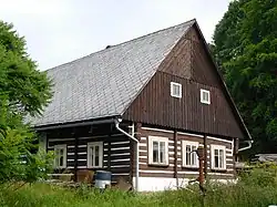 A log house protected as a cultural monument | |
 Horní Brusnice Location in the Czech Republic | |
| Coordinates: 50°28′23″N 15°40′52″E / 50.47306°N 15.68111°E | |
| Country | |
| Region | Hradec Králové |
| District | Trutnov |
| First mentioned | 1358 |
| Area | |
• Total | 14.10 km2 (5.44 sq mi) |
| Elevation | 453 m (1,486 ft) |
| Population (2025-01-01)[1] | |
• Total | 447 |
| • Density | 32/km2 (82/sq mi) |
| Time zone | UTC+1 (CET) |
| • Summer (DST) | UTC+2 (CEST) |
| Postal code | 544 74 |
| Website | www |
Horní Brusnice (German: Ober Prausnitz) is a municipality and village in Trutnov District in the Hradec Králové Region of the Czech Republic. It has about 400 inhabitants.
Demographics
| Year | Pop. | ±% |
|---|---|---|
| 1869 | 1,591 | — |
| 1880 | 1,597 | +0.4% |
| 1890 | 1,518 | −4.9% |
| 1900 | 1,408 | −7.2% |
| 1910 | 1,310 | −7.0% |
| 1921 | 1,255 | −4.2% |
| 1930 | 1,225 | −2.4% |
| 1950 | 777 | −36.6% |
| 1961 | 738 | −5.0% |
| 1970 | 662 | −10.3% |
| 1980 | 556 | −16.0% |
| 1991 | 492 | −11.5% |
| 2001 | 466 | −5.3% |
| 2011 | 425 | −8.8% |
| 2021 | 428 | +0.7% |
| Source: Censuses[2][3] | ||
Sights
The main landmark of Horní Brusnice is the Church of Saint Nicholas. It was built in the Neoclassical style in 1842–1846.[4]
References
- ^ "Population of Municipalities – 1 January 2025". Czech Statistical Office. 2025-05-16.
- ^ "Historický lexikon obcí České republiky 1869–2011" (in Czech). Czech Statistical Office. 2015-12-21.
- ^ "Population Census 2021: Population by sex". Public Database. Czech Statistical Office. 2021-03-27.
- ^ "Kostel sv. Mikuláše" (in Czech). National Heritage Institute. Retrieved 2024-02-05.
External links
Wikimedia Commons has media related to Horní Brusnice.