Bénarville
Bénarville | |
|---|---|
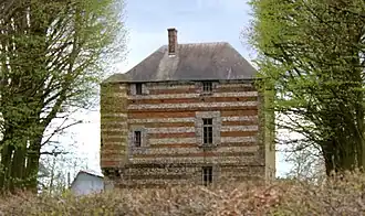 The fortified house of the Bois-Rozé, in Bénarville | |
.svg.png) Coat of arms | |
Location of Bénarville | |
 Bénarville  Bénarville | |
| Coordinates: 49°40′25″N 0°29′33″E / 49.6736°N 0.4925°E | |
| Country | France |
| Region | Normandy |
| Department | Seine-Maritime |
| Arrondissement | Le Havre |
| Canton | Saint-Romain-de-Colbosc |
| Intercommunality | CC Campagne de Caux |
| Government | |
| • Mayor (2020–2026) | Isabelle Geulin[1] |
Area 1 | 4.36 km2 (1.68 sq mi) |
| Population (2022)[2] | 262 |
| • Density | 60/km2 (160/sq mi) |
| Time zone | UTC+01:00 (CET) |
| • Summer (DST) | UTC+02:00 (CEST) |
| INSEE/Postal code | 76076 /76110 |
| Elevation | 75–136 m (246–446 ft) (avg. 125 m or 410 ft) |
| 1 French Land Register data, which excludes lakes, ponds, glaciers > 1 km2 (0.386 sq mi or 247 acres) and river estuaries. | |
Bénarville (French pronunciation: [benaʁvil]) is a commune in the Seine-Maritime department in the Normandy region in northern France.
Geography
A small farming village situated in the Pays de Caux, some 20 miles (32 km) northeast of Le Havre, at the junction of the D11 and D28 roads.
Population
| Year | Pop. | ±% p.a. |
|---|---|---|
| 1968 | 169 | — |
| 1975 | 171 | +0.17% |
| 1982 | 190 | +1.52% |
| 1990 | 213 | +1.44% |
| 1999 | 193 | −1.09% |
| 2007 | 237 | +2.60% |
| 2012 | 243 | +0.50% |
| 2017 | 265 | +1.75% |
| Source: INSEE[3] | ||
Places of interest
- The fifteenth century fortified house.
- The church of St.Germain, dating from the twelfth century.
See also
References
- ^ "Répertoire national des élus: les maires". data.gouv.fr, Plateforme ouverte des données publiques françaises (in French). 2 December 2020.
- ^ "Populations de référence 2022" (in French). The National Institute of Statistics and Economic Studies. 19 December 2024.
- ^ Population en historique depuis 1968, INSEE
External links
Wikimedia Commons has media related to Bénarville.