Boissay
Boissay | |
|---|---|
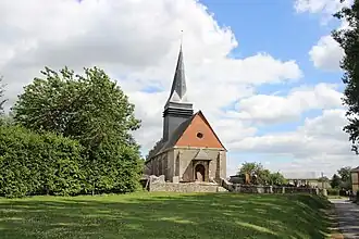 The Église Saint-Martin in Boissay | |
Location of Boissay | |
 Boissay  Boissay | |
| Coordinates: 49°31′12″N 1°21′30″E / 49.52°N 1.3583°E | |
| Country | France |
| Region | Normandy |
| Department | Seine-Maritime |
| Arrondissement | Rouen |
| Canton | Le Mesnil-Esnard |
| Government | |
| • Mayor (2020–2026) | Delphine Duramé[1] |
Area 1 | 6.63 km2 (2.56 sq mi) |
| Population (2022)[2] | 426 |
| • Density | 64/km2 (170/sq mi) |
| Time zone | UTC+01:00 (CET) |
| • Summer (DST) | UTC+02:00 (CEST) |
| INSEE/Postal code | 76113 /76750 |
| Elevation | 114–171 m (374–561 ft) (avg. 150 m or 490 ft) |
| 1 French Land Register data, which excludes lakes, ponds, glaciers > 1 km2 (0.386 sq mi or 247 acres) and river estuaries. | |
Boissay (French pronunciation: [bwasɛ]) is a commune in the Seine-Maritime department in the Normandy region in north-western France. It is the place of origin of the Boissay family.
Geography
It is a farming village situated in the Pays de Bray some 14 miles (23 km) northeast of Rouen at the junction of the D87, D93 and the D261 roads.
Population
| Year | Pop. | ±% p.a. |
|---|---|---|
| 1968 | 199 | — |
| 1975 | 203 | +0.28% |
| 1982 | 213 | +0.69% |
| 1990 | 241 | +1.56% |
| 1999 | 268 | +1.19% |
| 2007 | 291 | +1.03% |
| 2012 | 354 | +4.00% |
| 2017 | 406 | +2.78% |
| Source: INSEE[3] | ||
Places of interest
- The Église Saint-Martin, dating from the seventeenth century.
- An eighteenth-century dovecote.
See also
References
- ^ "Répertoire national des élus: les maires" (in French). data.gouv.fr, Plateforme ouverte des données publiques françaises. 13 September 2022.
- ^ "Populations de référence 2022" (in French). The National Institute of Statistics and Economic Studies. 19 December 2024.
- ^ Population en historique depuis 1968, INSEE
Wikimedia Commons has media related to Boissay.