Cejle
Cejle | |
|---|---|
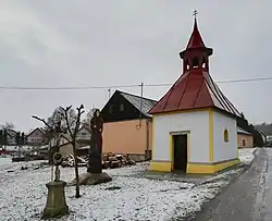 Chapel of Saint Margaret the Virgin | |
 Flag  Coat of arms | |
 Cejle Location in the Czech Republic | |
| Coordinates: 49°22′10″N 15°28′22″E / 49.36944°N 15.47278°E | |
| Country | |
| Region | Vysočina |
| District | Jihlava |
| First mentioned | 1360 |
| Area | |
• Total | 12.69 km2 (4.90 sq mi) |
| Elevation | 546 m (1,791 ft) |
| Population (2025-01-01)[1] | |
• Total | 508 |
| • Density | 40/km2 (100/sq mi) |
| Time zone | UTC+1 (CET) |
| • Summer (DST) | UTC+2 (CEST) |
| Postal code | 588 51 |
| Website | www |
Cejle (Czech pronunciation: [ˈtsɛjlɛ]) is a municipality and village in Jihlava District in the Vysočina Region of the Czech Republic. It has about 500 inhabitants.
Cejle lies approximately 9 kilometres (6 mi) south-west of Jihlava and 111 km (69 mi) south-east of Prague.
Administrative division
Cejle consists of two municipal parts (in brackets population according to the 2021 census):[2]
- Cejle (489)
- Hutě (27)
Demographics
| Year | Pop. | ±% |
|---|---|---|
| 1869 | 670 | — |
| 1880 | 656 | −2.1% |
| 1890 | 651 | −0.8% |
| 1900 | 688 | +5.7% |
| 1910 | 646 | −6.1% |
| 1921 | 670 | +3.7% |
| 1930 | 678 | +1.2% |
| 1950 | 485 | −28.5% |
| 1961 | 478 | −1.4% |
| 1970 | 405 | −15.3% |
| 1980 | 407 | +0.5% |
| 1991 | 379 | −6.9% |
| 2001 | 393 | +3.7% |
| 2011 | 442 | +12.5% |
| 2021 | 516 | +16.7% |
| Source: Censuses[3][4] | ||
References
- ^ "Population of Municipalities – 1 January 2025". Czech Statistical Office. 2025-05-16.
- ^ "Public Census 2021 – basic data". Public Database (in Czech). Czech Statistical Office. 2022.
- ^ "Historický lexikon obcí České republiky 1869–2011" (in Czech). Czech Statistical Office. 2015-12-21.
- ^ "Population Census 2021: Population by sex". Public Database. Czech Statistical Office. 2021-03-27.
External links
Wikimedia Commons has media related to Cejle.