Záborná
Záborná | |
|---|---|
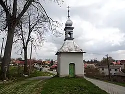 Chapel of Our Lady of Sorrows | |
 Flag  Coat of arms | |
 Záborná Location in the Czech Republic | |
| Coordinates: 49°49′12″N 15°45′25″E / 49.82000°N 15.75694°E | |
| Country | |
| Region | Vysočina |
| District | Jihlava |
| First mentioned | 1282 |
| Area | |
• Total | 6.45 km2 (2.49 sq mi) |
| Elevation | 527 m (1,729 ft) |
| Population (2025-01-01)[1] | |
• Total | 250 |
| • Density | 39/km2 (100/sq mi) |
| Time zone | UTC+1 (CET) |
| • Summer (DST) | UTC+2 (CEST) |
| Postal code | 588 13 |
| Website | www |
Záborná (Czech pronunciation: [ˈzaːbornaː]) is a municipality and village in Jihlava District in the Vysočina Region of the Czech Republic. It has about 300 inhabitants.
Záborná lies approximately 16 kilometres (10 mi) north-east of Jihlava and 118 km (73 mi) south-east of Prague.
Demographics
| Year | Pop. | ±% |
|---|---|---|
| 1869 | 319 | — |
| 1880 | 380 | +19.1% |
| 1890 | 338 | −11.1% |
| 1900 | 333 | −1.5% |
| 1910 | 344 | +3.3% |
| 1921 | 374 | +8.7% |
| 1930 | 327 | −12.6% |
| 1950 | 269 | −17.7% |
| 1961 | 269 | +0.0% |
| 1970 | 254 | −5.6% |
| 1980 | 237 | −6.7% |
| 1991 | 210 | −11.4% |
| 2001 | 210 | +0.0% |
| 2011 | 232 | +10.5% |
| 2021 | 254 | +9.5% |
| Source: Censuses[2][3] | ||
References
- ^ "Population of Municipalities – 1 January 2025". Czech Statistical Office. 2025-05-16.
- ^ "Historický lexikon obcí České republiky 1869–2011" (in Czech). Czech Statistical Office. 2015-12-21.
- ^ "Population Census 2021: Population by sex". Public Database. Czech Statistical Office. 2021-03-27.
External links
Wikimedia Commons has media related to Záborná.