Jamné
Jamné | |
|---|---|
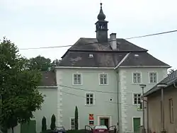 Jamné Castle | |
 Flag  Coat of arms | |
 Jamné Location in the Czech Republic | |
| Coordinates: 49°25′52″N 15°43′26″E / 49.43111°N 15.72389°E | |
| Country | |
| Region | Vysočina |
| District | Jihlava |
| First mentioned | 1444 |
| Area | |
• Total | 11.19 km2 (4.32 sq mi) |
| Elevation | 514 m (1,686 ft) |
| Population (2025-01-01)[1] | |
• Total | 583 |
| • Density | 52/km2 (130/sq mi) |
| Time zone | UTC+1 (CET) |
| • Summer (DST) | UTC+2 (CEST) |
| Postal code | 588 27 |
| Website | www |
Jamné (Czech pronunciation: [ˈjamnɛː]) is a municipality and village in Jihlava District in the Vysočina Region of the Czech Republic. It has about 600 inhabitants.
Jamné lies approximately 11 kilometres (7 mi) north-east of Jihlava and 119 km (74 mi) south-east of Prague.
Administrative division
Jamné consists of two municipal parts (in brackets population according to the 2021 census):[2]
- Jamné (540)
- Lipina (15)
Demographics
| Year | Pop. | ±% |
|---|---|---|
| 1869 | 527 | — |
| 1880 | 584 | +10.8% |
| 1890 | 606 | +3.8% |
| 1900 | 668 | +10.2% |
| 1910 | 638 | −4.5% |
| 1921 | 633 | −0.8% |
| 1930 | 661 | +4.4% |
| 1950 | 567 | −14.2% |
| 1961 | 596 | +5.1% |
| 1970 | 542 | −9.1% |
| 1980 | 488 | −10.0% |
| 1991 | 447 | −8.4% |
| 2001 | 490 | +9.6% |
| 2011 | 515 | +5.1% |
| 2021 | 555 | +7.8% |
| Source: Censuses[3][4] | ||
References
- ^ "Population of Municipalities – 1 January 2025". Czech Statistical Office. 2025-05-16.
- ^ "Public Census 2021 – basic data". Public Database (in Czech). Czech Statistical Office. 2022.
- ^ "Historický lexikon obcí České republiky 1869–2011" (in Czech). Czech Statistical Office. 2015-12-21.
- ^ "Population Census 2021: Population by sex". Public Database. Czech Statistical Office. 2021-03-27.
External links
Wikimedia Commons has media related to Jamné.