Dědová
Dědová | |
|---|---|
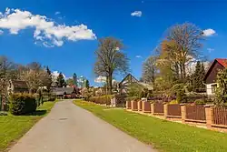 A street in Dědová | |
 Flag  Coat of arms | |
 Dědová Location in the Czech Republic | |
| Coordinates: 49°45′40″N 15°59′11″E / 49.76111°N 15.98639°E | |
| Country | |
| Region | Pardubice |
| District | Chrudim |
| First mentioned | 1392 |
| Area | |
• Total | 3.90 km2 (1.51 sq mi) |
| Elevation | 658 m (2,159 ft) |
| Population (2025-01-01)[1] | |
• Total | 125 |
| • Density | 32/km2 (83/sq mi) |
| Time zone | UTC+1 (CET) |
| • Summer (DST) | UTC+2 (CEST) |
| Postal code | 539 01 |
| Website | web |
Dědová is a municipality and village in Chrudim District in the Pardubice Region of the Czech Republic. It has about 100 inhabitants.
Demographics
| Year | Pop. | ±% |
|---|---|---|
| 1869 | 544 | — |
| 1880 | 531 | −2.4% |
| 1890 | 489 | −7.9% |
| 1900 | 481 | −1.6% |
| 1910 | 482 | +0.2% |
| 1921 | 440 | −8.7% |
| 1930 | 430 | −2.3% |
| 1950 | 331 | −23.0% |
| 1961 | 313 | −5.4% |
| 1970 | 253 | −19.2% |
| 1980 | 211 | −16.6% |
| 1991 | 173 | −18.0% |
| 2001 | 168 | −2.9% |
| 2011 | 149 | −11.3% |
| 2021 | 132 | −11.4% |
| Source: Censuses[2][3] | ||
References
- ^ "Population of Municipalities – 1 January 2025". Czech Statistical Office. 2025-05-16.
- ^ "Historický lexikon obcí České republiky 1869–2011" (in Czech). Czech Statistical Office. 2015-12-21.
- ^ "Population Census 2021: Population by sex". Public Database. Czech Statistical Office. 2021-03-27.
External links
Wikimedia Commons has media related to Dědová.