Jeníkov (Chrudim District)
Jeníkov | |
|---|---|
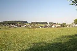 View from the east | |
 Flag  Coat of arms | |
 Jeníkov Location in the Czech Republic | |
| Coordinates: 49°44′33″N 15°57′27″E / 49.74250°N 15.95750°E | |
| Country | |
| Region | Pardubice |
| District | Chrudim |
| First mentioned | 1392 |
| Area | |
• Total | 5.82 km2 (2.25 sq mi) |
| Elevation | 648 m (2,126 ft) |
| Population (2025-01-01)[1] | |
• Total | 455 |
| • Density | 78/km2 (200/sq mi) |
| Time zone | UTC+1 (CET) |
| • Summer (DST) | UTC+2 (CEST) |
| Postal code | 539 01 |
| Website | www |
Jeníkov is a municipality and village in Chrudim District in the Pardubice Region of the Czech Republic. It has about 500 inhabitants.
Demographics
| Year | Pop. | ±% |
|---|---|---|
| 1869 | 539 | — |
| 1880 | 554 | +2.8% |
| 1890 | 583 | +5.2% |
| 1900 | 565 | −3.1% |
| 1910 | 572 | +1.2% |
| 1921 | 558 | −2.4% |
| 1930 | 595 | +6.6% |
| 1950 | 497 | −16.5% |
| 1961 | 527 | +6.0% |
| 1970 | 500 | −5.1% |
| 1980 | 453 | −9.4% |
| 1991 | 445 | −1.8% |
| 2001 | 474 | +6.5% |
| 2011 | 469 | −1.1% |
| 2021 | 446 | −4.9% |
| Source: Censuses[2][3] | ||
References
- ^ "Population of Municipalities – 1 January 2025". Czech Statistical Office. 2025-05-16.
- ^ "Historický lexikon obcí České republiky 1869–2011" (in Czech). Czech Statistical Office. 2015-12-21.
- ^ "Population Census 2021: Population by sex". Public Database. Czech Statistical Office. 2021-03-27.
External links
Wikimedia Commons has media related to Jeníkov (Chrudim District).