Trojovice
Trojovice | |
|---|---|
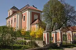 Church of Saint Michael the Archangel | |
 Flag 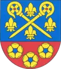 Coat of arms | |
 Trojovice Location in the Czech Republic | |
| Coordinates: 49°55′58″N 15°55′11″E / 49.93278°N 15.91972°E | |
| Country | |
| Region | Pardubice |
| District | Chrudim |
| First mentioned | 1244 |
| Area | |
• Total | 2.73 km2 (1.05 sq mi) |
| Elevation | 252 m (827 ft) |
| Population (2025-01-01)[1] | |
• Total | 183 |
| • Density | 67/km2 (170/sq mi) |
| Time zone | UTC+1 (CET) |
| • Summer (DST) | UTC+2 (CEST) |
| Postal code | 538 33 |
| Website | www |
Trojovice is a municipality and village in Chrudim District in the Pardubice Region of the Czech Republic. It has about 200 inhabitants.
Demographics
| Year | Pop. | ±% |
|---|---|---|
| 1869 | 373 | — |
| 1880 | 396 | +6.2% |
| 1890 | 401 | +1.3% |
| 1900 | 381 | −5.0% |
| 1910 | 404 | +6.0% |
| 1921 | 373 | −7.7% |
| 1930 | 335 | −10.2% |
| 1950 | 270 | −19.4% |
| 1961 | 271 | +0.4% |
| 1970 | 247 | −8.9% |
| 1980 | 217 | −12.1% |
| 1991 | 186 | −14.3% |
| 2001 | 194 | +4.3% |
| 2011 | 191 | −1.5% |
| 2021 | 180 | −5.8% |
| Source: Censuses[2][3] | ||
References
- ^ "Population of Municipalities – 1 January 2025". Czech Statistical Office. 2025-05-16.
- ^ "Historický lexikon obcí České republiky 1869–2011" (in Czech). Czech Statistical Office. 2015-12-21.
- ^ "Population Census 2021: Population by sex". Public Database. Czech Statistical Office. 2021-03-27.
External links
Wikimedia Commons has media related to Trojovice.