Gratentour
Gratentour | |
|---|---|
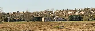 A general view of Gratentour | |
.svg.png) Coat of arms | |
Location of Gratentour | |
 Gratentour  Gratentour | |
| Coordinates: 43°43′19″N 1°25′56″E / 43.7219°N 1.4322°E | |
| Country | France |
| Region | Occitania |
| Department | Haute-Garonne |
| Arrondissement | Toulouse |
| Canton | Castelginest |
| Intercommunality | Toulouse Métropole |
| Government | |
| • Mayor (2020–2026) | Patrick Delpech[1] |
Area 1 | 4.09 km2 (1.58 sq mi) |
| Population (2022)[2] | 4,926 |
| • Density | 1,200/km2 (3,100/sq mi) |
| Time zone | UTC+01:00 (CET) |
| • Summer (DST) | UTC+02:00 (CEST) |
| INSEE/Postal code | 31230 /31150 |
| Elevation | 123–194 m (404–636 ft) (avg. 170 m or 560 ft) |
| 1 French Land Register data, which excludes lakes, ponds, glaciers > 1 km2 (0.386 sq mi or 247 acres) and river estuaries. | |
Gratentour (French pronunciation: [ɡʁatɛ̃tuʁ]; Occitan: Gratentorn) is a commune in the Haute-Garonne department in southwestern France.
Population
| Year | Pop. | ±% p.a. |
|---|---|---|
| 1968 | 646 | — |
| 1975 | 924 | +5.25% |
| 1982 | 1,574 | +7.91% |
| 1990 | 2,518 | +6.05% |
| 1999 | 3,035 | +2.10% |
| 2007 | 3,662 | +2.38% |
| 2012 | 3,552 | −0.61% |
| 2017 | 4,158 | +3.20% |
| Source: INSEE[3] | ||
Monument
-
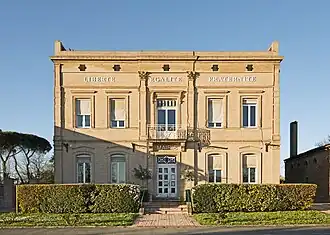 Town hall
 -
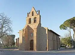 Sainte Quitterie church
 -
 Bell gabel of Sainte Quitterie church
See also
References
- ^ "Répertoire national des élus: les maires". data.gouv.fr, Plateforme ouverte des données publiques françaises (in French). 2 December 2020.
- ^ "Populations de référence 2022" (in French). The National Institute of Statistics and Economic Studies. 19 December 2024.
- ^ Population en historique depuis 1968, INSEE
Wikimedia Commons has media related to Gratentour.