Jarohněvice
Jarohněvice | |
|---|---|
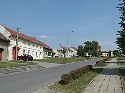 Centre of Jarohněvice | |
 Flag  Coat of arms | |
 Jarohněvice Location in the Czech Republic | |
| Coordinates: 49°16′2″N 17°22′39″E / 49.26722°N 17.37750°E | |
| Country | |
| Region | Zlín |
| District | Kroměříž |
| First mentioned | 1267 |
| Area | |
• Total | 4.99 km2 (1.93 sq mi) |
| Elevation | 207 m (679 ft) |
| Population (2025-01-01)[1] | |
• Total | 314 |
| • Density | 63/km2 (160/sq mi) |
| Time zone | UTC+1 (CET) |
| • Summer (DST) | UTC+2 (CEST) |
| Postal code | 768 01 |
| Website | www |
Jarohněvice is a municipality and village in Kroměříž District in the Zlín Region of the Czech Republic. It has about 300 inhabitants.
Jarohněvice lies approximately 5 kilometres (3 mi) south-west of Kroměříž, 23 km (14 mi) west of Zlín, and 231 km (144 mi) south-east of Prague.
Demographics
| Year | Pop. | ±% |
|---|---|---|
| 1869 | 380 | — |
| 1880 | 421 | +10.8% |
| 1890 | 418 | −0.7% |
| 1900 | 440 | +5.3% |
| 1910 | 453 | +3.0% |
| 1921 | 422 | −6.8% |
| 1930 | 386 | −8.5% |
| 1950 | 294 | −23.8% |
| 1961 | 300 | +2.0% |
| 1970 | 267 | −11.0% |
| 1980 | 225 | −15.7% |
| 1991 | 208 | −7.6% |
| 2001 | 231 | +11.1% |
| 2011 | 311 | +34.6% |
| 2021 | 306 | −1.6% |
| Source: Censuses[2][3] | ||
References
- ^ "Population of Municipalities – 1 January 2025". Czech Statistical Office. 2025-05-16.
- ^ "Historický lexikon obcí České republiky 1869–2011" (in Czech). Czech Statistical Office. 2015-12-21.
- ^ "Population Census 2021: Population by sex". Public Database. Czech Statistical Office. 2021-03-27.
External links
Wikimedia Commons has media related to Jarohněvice.