Kostelec u Holešova
Kostelec u Holešova | |
|---|---|
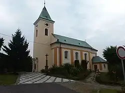 Church of Saints Peter and Paul | |
 Flag  Coat of arms | |
 Kostelec u Holešova Location in the Czech Republic | |
| Coordinates: 49°22′29″N 17°30′44″E / 49.37472°N 17.51222°E | |
| Country | |
| Region | Zlín |
| District | Kroměříž |
| First mentioned | 1131 |
| Area | |
• Total | 15.03 km2 (5.80 sq mi) |
| Elevation | 260 m (850 ft) |
| Population (2025-01-01)[1] | |
• Total | 979 |
| • Density | 65/km2 (170/sq mi) |
| Time zone | UTC+1 (CET) |
| • Summer (DST) | UTC+2 (CEST) |
| Postal code | 768 43 |
| Website | www |
Kostelec u Holešova is a municipality and village in Kroměříž District in the Zlín Region of the Czech Republic. It has about 1,000 inhabitants.
Kostelec u Holešova lies approximately 13 kilometres (8 mi) north-east of Kroměříž, 19 km (12 mi) north-west of Zlín, and 237 km (147 mi) east of Prague.
Administrative division
Kostelec u Holešova consists of two municipal parts (in brackets population according to the 2021 census):[2]
- Kostelec u Holešova (860)
- Karlovice (122)
Demographics
| Year | Pop. | ±% |
|---|---|---|
| 1869 | 993 | — |
| 1880 | 1,053 | +6.0% |
| 1890 | 1,074 | +2.0% |
| 1900 | 1,137 | +5.9% |
| 1910 | 1,199 | +5.5% |
| 1921 | 1,137 | −5.2% |
| 1930 | 1,099 | −3.3% |
| 1950 | 1,039 | −5.5% |
| 1961 | 1,058 | +1.8% |
| 1970 | 964 | −8.9% |
| 1980 | 875 | −9.2% |
| 1991 | 913 | +4.3% |
| 2001 | 976 | +6.9% |
| 2011 | 966 | −1.0% |
| 2021 | 982 | +1.7% |
| Source: Censuses[3][4] | ||
References
- ^ "Population of Municipalities – 1 January 2025". Czech Statistical Office. 2025-05-16.
- ^ "Public Census 2021 – basic data". Public Database (in Czech). Czech Statistical Office. 2022.
- ^ "Historický lexikon obcí České republiky 1869–2011" (in Czech). Czech Statistical Office. 2015-12-21.
- ^ "Population Census 2021: Population by sex". Public Database. Czech Statistical Office. 2021-03-27.
External links
Wikimedia Commons has media related to Kostelec u Holešova.