Podhradní Lhota
Podhradní Lhota | |
|---|---|
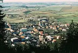 View from the south | |
 Flag  Coat of arms | |
 Podhradní Lhota Location in the Czech Republic | |
| Coordinates: 49°25′15″N 17°47′42″E / 49.42083°N 17.79500°E | |
| Country | |
| Region | Zlín |
| District | Kroměříž |
| First mentioned | 1271 |
| Area | |
• Total | 3.81 km2 (1.47 sq mi) |
| Elevation | 386 m (1,266 ft) |
| Population (2025-01-01)[1] | |
• Total | 456 |
| • Density | 120/km2 (310/sq mi) |
| Time zone | UTC+1 (CET) |
| • Summer (DST) | UTC+2 (CEST) |
| Postal code | 768 71 |
| Website | www |
Podhradní Lhota is a municipality and village in Kroměříž District in the Zlín Region of the Czech Republic. It has about 500 inhabitants.
Podhradní Lhota lies approximately 33 kilometres (21 mi) north-east of Kroměříž, 23 km (14 mi) north-east of Zlín, and 254 km (158 mi) east of Prague.
Demographics
| Year | Pop. | ±% |
|---|---|---|
| 1869 | 504 | — |
| 1880 | 508 | +0.8% |
| 1890 | 467 | −8.1% |
| 1900 | 468 | +0.2% |
| 1910 | 491 | +4.9% |
| 1921 | 511 | +4.1% |
| 1930 | 547 | +7.0% |
| 1950 | 530 | −3.1% |
| 1961 | 582 | +9.8% |
| 1970 | 552 | −5.2% |
| 1980 | 538 | −2.5% |
| 1991 | 515 | −4.3% |
| 2001 | 533 | +3.5% |
| 2011 | 512 | −3.9% |
| 2021 | 430 | −16.0% |
| Source: Censuses[2][3] | ||
Sights
Ruins of the Nový Šaumburk castle is located in the municipality.
References
- ^ "Population of Municipalities – 1 January 2025". Czech Statistical Office. 2025-05-16.
- ^ "Historický lexikon obcí České republiky 1869–2011" (in Czech). Czech Statistical Office. 2015-12-21.
- ^ "Population Census 2021: Population by sex". Public Database. Czech Statistical Office. 2021-03-27.
External links
Wikimedia Commons has media related to Podhradní Lhota.