Montriond
Montriond | |
|---|---|
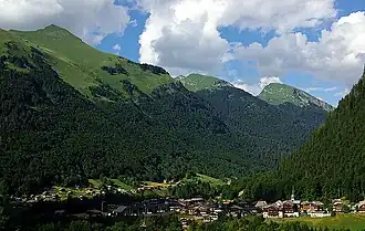 Montriond village | |
 Coat of arms | |
Location of Montriond | |
 Montriond  Montriond | |
| Coordinates: 46°11′53″N 6°41′42″E / 46.1981°N 6.695°E | |
| Country | France |
| Region | Auvergne-Rhône-Alpes |
| Department | Haute-Savoie |
| Arrondissement | Thonon-les-Bains |
| Canton | Évian-les-Bains |
| Intercommunality | Haut-Chablais |
| Government | |
| • Mayor (2020–2026) | Jean-Claude Denne[1] |
Area 1 | 24.71 km2 (9.54 sq mi) |
| Population (2022)[2] | 956 |
| • Density | 39/km2 (100/sq mi) |
| Time zone | UTC+01:00 (CET) |
| • Summer (DST) | UTC+02:00 (CEST) |
| INSEE/Postal code | 74188 /74110 |
| Elevation | 877–2,340 m (2,877–7,677 ft) |
| 1 French Land Register data, which excludes lakes, ponds, glaciers > 1 km2 (0.386 sq mi or 247 acres) and river estuaries. | |
Montriond (French pronunciation: [mɔ̃tʁijɔ̃]; Arpitan: Meûryan) is a commune in the Haute-Savoie department in the Auvergne-Rhône-Alpes region in south-eastern France.
It is just north of the ski resorts of Morzine and Avoriaz in the Portes du Soleil ski resorts area. Just east lies Lac de Montriond, a small lake. Montriond's village centre features a small supermarket, ski/outdoors retailer and several restaurants as well as a tourist information office and a Mairie.
See also
References
- ^ "Répertoire national des élus: les maires" (in French). data.gouv.fr, Plateforme ouverte des données publiques françaises. 13 September 2022.
- ^ "Populations de référence 2022" (in French). The National Institute of Statistics and Economic Studies. 19 December 2024.
Wikimedia Commons has media related to Montriond.