Popelín
Popelín | |
|---|---|
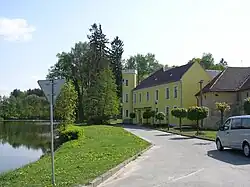 Popelín Castle, today a primary school | |
 Flag  Coat of arms | |
 Popelín Location in the Czech Republic | |
| Coordinates: 49°12′49″N 15°11′2″E / 49.21361°N 15.18389°E | |
| Country | |
| Region | South Bohemian |
| District | Jindřichův Hradec |
| First mentioned | 1349 |
| Area | |
• Total | 13.47 km2 (5.20 sq mi) |
| Elevation | 575 m (1,886 ft) |
| Population (2025-01-01)[1] | |
• Total | 471 |
| • Density | 35/km2 (91/sq mi) |
| Time zone | UTC+1 (CET) |
| • Summer (DST) | UTC+2 (CEST) |
| Postal codes | 378 53, 378 55 |
| Website | www |
Popelín is a municipality and village in Jindřichův Hradec District in the South Bohemian Region of the Czech Republic. It has about 500 inhabitants.
Popelín lies approximately 16 kilometres (10 mi) north-east of Jindřichův Hradec, 59 km (37 mi) north-east of České Budějovice, and 112 km (70 mi) south-east of Prague.
Administrative division
Popelín consists of two municipal parts (in brackets population according to the 2021 census):[2]
- Popelín (388)
- Horní Olešná (80)
Demographics
| Year | Pop. | ±% |
|---|---|---|
| 1869 | 1,008 | — |
| 1880 | 994 | −1.4% |
| 1890 | 1,017 | +2.3% |
| 1900 | 1,062 | +4.4% |
| 1910 | 1,106 | +4.1% |
| 1921 | 1,160 | +4.9% |
| 1930 | 1,112 | −4.1% |
| 1950 | 776 | −30.2% |
| 1961 | 781 | +0.6% |
| 1970 | 633 | −19.0% |
| 1980 | 527 | −16.7% |
| 1991 | 493 | −6.5% |
| 2001 | 442 | −10.3% |
| 2011 | 474 | +7.2% |
| 2021 | 468 | −1.3% |
| Source: Censuses[3][4] | ||
References
- ^ "Population of Municipalities – 1 January 2025". Czech Statistical Office. 2025-05-16.
- ^ "Public Census 2021 – basic data". Public Database (in Czech). Czech Statistical Office. 2022.
- ^ "Historický lexikon obcí České republiky 1869–2011" (in Czech). Czech Statistical Office. 2015-12-21.
- ^ "Population Census 2021: Population by sex". Public Database. Czech Statistical Office. 2021-03-27.
External links
Wikimedia Commons has media related to Popelín.