Prokopov
Prokopov | |
|---|---|
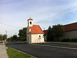 Chapel of the Virgin Mary | |
 Flag  Coat of arms | |
 Prokopov Location in the Czech Republic | |
| Coordinates: 48°59′54″N 15°53′46″E / 48.99833°N 15.89611°E | |
| Country | |
| Region | South Moravian |
| District | Znojmo |
| First mentioned | 1789 |
| Area | |
• Total | 2.45 km2 (0.95 sq mi) |
| Elevation | 388 m (1,273 ft) |
| Population (2025-01-01)[1] | |
• Total | 106 |
| • Density | 43/km2 (110/sq mi) |
| Time zone | UTC+1 (CET) |
| • Summer (DST) | UTC+2 (CEST) |
| Postal code | 671 54 |
| Website | www |
Prokopov (German: Prokopsdorf) is a municipality and village in Znojmo District in the South Moravian Region of the Czech Republic. It has about 100 inhabitants.
Prokopov lies approximately 19 kilometres (12 mi) north-west of Znojmo, 58 km (36 mi) south-west of Brno, and 162 km (101 mi) south-east of Prague.
Demographics
| Year | Pop. | ±% |
|---|---|---|
| 1869 | 207 | — |
| 1880 | 180 | −13.0% |
| 1890 | 168 | −6.7% |
| 1900 | 208 | +23.8% |
| 1910 | 230 | +10.6% |
| 1921 | 285 | +23.9% |
| 1930 | 261 | −8.4% |
| 1950 | 180 | −31.0% |
| 1961 | 169 | −6.1% |
| 1970 | 136 | −19.5% |
| 1980 | 126 | −7.4% |
| 1991 | 106 | −15.9% |
| 2001 | 95 | −10.4% |
| 2011 | 107 | +12.6% |
| 2021 | 86 | −19.6% |
| Source: Censuses[2][3] | ||
References
- ^ "Population of Municipalities – 1 January 2025". Czech Statistical Office. 2025-05-16.
- ^ "Historický lexikon obcí České republiky 1869–2011" (in Czech). Czech Statistical Office. 2015-12-21.
- ^ "Population Census 2021: Population by sex". Public Database. Czech Statistical Office. 2021-03-27.
External links
Wikimedia Commons has media related to Prokopov.