Sainte-Engrâce
Sainte-Engrâce
Santa Grazi | |
|---|---|
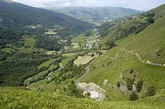 View of Sainte-Engrâce in the Uhaitxa Valley | |
Location of Sainte-Engrâce | |
 Sainte-Engrâce  Sainte-Engrâce | |
| Coordinates: 43°00′54″N 0°51′10″W / 43.015°N 0.8527°W | |
| Country | France |
| Region | Nouvelle-Aquitaine |
| Department | Pyrénées-Atlantiques |
| Arrondissement | Oloron-Sainte-Marie |
| Canton | Montagne Basque |
| Intercommunality | CA Pays Basque |
| Government | |
| • Mayor (2020–2026) | Maryse Othart[1] |
Area 1 | 72.69 km2 (28.07 sq mi) |
| Population (2022)[2] | 172 |
| • Density | 2.4/km2 (6.1/sq mi) |
| Time zone | UTC+01:00 (CET) |
| • Summer (DST) | UTC+02:00 (CEST) |
| INSEE/Postal code | 64475 /64560 |
| Elevation | 300–1,881 m (984–6,171 ft) (avg. 650 m or 2,130 ft) |
| 1 French Land Register data, which excludes lakes, ponds, glaciers > 1 km2 (0.386 sq mi or 247 acres) and river estuaries. | |
Sainte-Engrâce (French pronunciation: [sɛ̃t ɑ̃ɡʁas]; Basque: Urdatx-Santa-Grazi)[3] is a commune in the Pyrénées-Atlantiques department in south-western France.[4] It is located in the former province of Soule.[3]
See also
References
- ^ "Répertoire national des élus: les maires". data.gouv.fr, Plateforme ouverte des données publiques françaises (in French). 2 December 2020.
- ^ "Populations de référence 2022" (in French). The National Institute of Statistics and Economic Studies. 19 December 2024.
- ^ a b URDATX-SANTA-GRAZI, Auñamendi Eusko Entziklopedia (in Spanish)
- ^ INSEE commune file
Wikimedia Commons has media related to Sainte-Engrâce.