Bréhand
Bréhand
Brehant-Monkontour | |
|---|---|
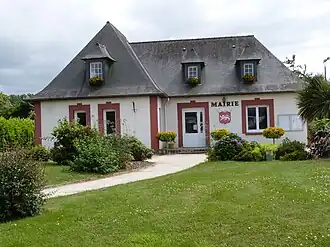 The town hall of Bréhand | |
 Flag  Coat of arms | |
Location of Bréhand | |
 Bréhand  Bréhand | |
| Coordinates: 48°24′13″N 2°34′23″W / 48.4036°N 2.573°W | |
| Country | France |
| Region | Brittany |
| Department | Côtes-d'Armor |
| Arrondissement | Saint-Brieuc |
| Canton | Plénée-Jugon |
| Intercommunality | CA Lamballe Terre et Mer |
| Government | |
| • Mayor (2020–2026) | Yves Ruffet[1] |
Area 1 | 24.95 km2 (9.63 sq mi) |
| Population (2022)[2] | 1,695 |
| • Density | 68/km2 (180/sq mi) |
| Time zone | UTC+01:00 (CET) |
| • Summer (DST) | UTC+02:00 (CEST) |
| INSEE/Postal code | 22015 /22510 |
| Elevation | 58–150 m (190–492 ft) |
| 1 French Land Register data, which excludes lakes, ponds, glaciers > 1 km2 (0.386 sq mi or 247 acres) and river estuaries. | |
Bréhand (French pronunciation: [bʁeɑ̃]; Breton: Brehant-Monkontour; Gallo: Berhaund-Moncontór) is a commune in the Côtes-d'Armor department of Brittany in northwestern France.
Population
| Year | Pop. | ±% |
|---|---|---|
| 1962 | 1,290 | — |
| 1968 | 1,307 | +1.3% |
| 1975 | 1,247 | −4.6% |
| 1982 | 1,369 | +9.8% |
| 1990 | 1,287 | −6.0% |
| 1999 | 1,271 | −1.2% |
| 2008 | 1,421 | +11.8% |
Inhabitants of Bréhand are called Bréhandais in French.
See also
References
- ^ "Répertoire national des élus: les maires". data.gouv.fr, Plateforme ouverte des données publiques françaises (in French). 2 December 2020.
- ^ "Populations de référence 2022" (in French). The National Institute of Statistics and Economic Studies. 19 December 2024.
Wikimedia Commons has media related to Bréhand.