Mantallot
Mantallot
Mantallod | |
|---|---|
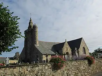 The church of Saint-Mérin, in Mantallot | |
Location of Mantallot | |
 Mantallot  Mantallot | |
| Coordinates: 48°42′29″N 3°17′51″W / 48.7081°N 3.2975°W | |
| Country | France |
| Region | Brittany |
| Department | Côtes-d'Armor |
| Arrondissement | Lannion |
| Canton | Bégard |
| Intercommunality | Lannion-Trégor Communauté |
| Government | |
| • Mayor (2020–2026) | Jean Droumaguet[1] |
Area 1 | 2.76 km2 (1.07 sq mi) |
| Population (2022)[2] | 234 |
| • Density | 85/km2 (220/sq mi) |
| Time zone | UTC+01:00 (CET) |
| • Summer (DST) | UTC+02:00 (CEST) |
| INSEE/Postal code | 22141 /22450 |
| Elevation | 18–87 m (59–285 ft) |
| 1 French Land Register data, which excludes lakes, ponds, glaciers > 1 km2 (0.386 sq mi or 247 acres) and river estuaries. | |
Mantallot (Breton: Mantallod) is a commune in the Côtes-d'Armor department of Brittany in northwestern France.
Population
| Year | Pop. | ±% |
|---|---|---|
| 1962 | 121 | — |
| 1968 | 148 | +22.3% |
| 1975 | 144 | −2.7% |
| 1982 | 132 | −8.3% |
| 1990 | 163 | +23.5% |
| 1999 | 171 | +4.9% |
| 2008 | 187 | +9.4% |
Inhabitants of Mantallot are called mantallotois in French.
See also
References
- ^ "Répertoire national des élus: les maires". data.gouv.fr, Plateforme ouverte des données publiques françaises (in French). 2 December 2020.
- ^ "Populations de référence 2022" (in French). The National Institute of Statistics and Economic Studies. 19 December 2024.
Wikimedia Commons has media related to Mantallot.