Branišovice
Branišovice | |
|---|---|
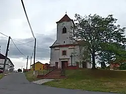 Church of Saint Lawrence | |
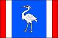 Flag  Coat of arms | |
 Branišovice Location in the Czech Republic | |
| Coordinates: 48°57′46″N 16°25′55″E / 48.96278°N 16.43194°E | |
| Country | |
| Region | South Moravian |
| District | Brno-Country |
| First mentioned | 1222 |
| Area | |
• Total | 11.06 km2 (4.27 sq mi) |
| Elevation | 194 m (636 ft) |
| Population (2025-01-01)[1] | |
• Total | 645 |
| • Density | 58/km2 (150/sq mi) |
| Time zone | UTC+1 (CET) |
| • Summer (DST) | UTC+2 (CEST) |
| Postal code | 671 77 |
| Website | www |
Branišovice (German: Frainspitz) is a municipality and village in Brno-Country District in the South Moravian Region of the Czech Republic. It has about 600 inhabitants.
Branišovice lies approximately 30 kilometres (19 mi) south-west of Brno and 192 km (119 mi) south-east of Prague.
Demographics
| Year | Pop. | ±% |
|---|---|---|
| 1869 | 738 | — |
| 1880 | 814 | +10.3% |
| 1890 | 830 | +2.0% |
| 1900 | 798 | −3.9% |
| 1910 | 852 | +6.8% |
| 1921 | 873 | +2.5% |
| 1930 | 861 | −1.4% |
| 1950 | 518 | −39.8% |
| 1961 | 569 | +9.8% |
| 1970 | 542 | −4.7% |
| 1980 | 554 | +2.2% |
| 1991 | 485 | −12.5% |
| 2001 | 507 | +4.5% |
| 2011 | 553 | +9.1% |
| 2021 | 590 | +6.7% |
| Source: Censuses[2][3] | ||
References
- ^ "Population of Municipalities – 1 January 2025". Czech Statistical Office. 2025-05-16.
- ^ "Historický lexikon obcí České republiky 1869–2011" (in Czech). Czech Statistical Office. 2015-12-21.
- ^ "Population Census 2021: Population by sex". Public Database. Czech Statistical Office. 2021-03-27.
External links
Wikimedia Commons has media related to Branišovice.