Svatoslav (Brno-Country District)
Svatoslav | |
|---|---|
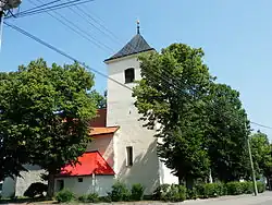 Church of the Assumption of the Virgin Mary | |
 Flag _znak.jpg) Coat of arms | |
 Svatoslav Location in the Czech Republic | |
| Coordinates: 49°18′6″N 16°18′32″E / 49.30167°N 16.30889°E | |
| Country | |
| Region | South Moravian |
| District | Brno-Country |
| First mentioned | 1240 |
| Area | |
• Total | 8.48 km2 (3.27 sq mi) |
| Elevation | 482 m (1,581 ft) |
| Population (2025-01-01)[1] | |
• Total | 461 |
| • Density | 54/km2 (140/sq mi) |
| Time zone | UTC+1 (CET) |
| • Summer (DST) | UTC+2 (CEST) |
| Postal code | 666 01 |
| Website | www |
Svatoslav is a municipality and village in Brno-Country District in the South Moravian Region of the Czech Republic. It has about 500 inhabitants.
Svatoslav lies approximately 26 kilometres (16 mi) north-west of Brno and 162 km (101 mi) south-east of Prague.
Demographics
| Year | Pop. | ±% |
|---|---|---|
| 1869 | 637 | — |
| 1880 | 680 | +6.8% |
| 1890 | 652 | −4.1% |
| 1900 | 652 | +0.0% |
| 1910 | 698 | +7.1% |
| 1921 | 682 | −2.3% |
| 1930 | 662 | −2.9% |
| 1950 | 524 | −20.8% |
| 1961 | 523 | −0.2% |
| 1970 | 541 | +3.4% |
| 1980 | 477 | −11.8% |
| 1991 | 444 | −6.9% |
| 2001 | 438 | −1.4% |
| 2011 | 425 | −3.0% |
| 2021 | 433 | +1.9% |
| Source: Censuses[2][3] | ||
References
- ^ "Population of Municipalities – 1 January 2025". Czech Statistical Office. 2025-05-16.
- ^ "Historický lexikon obcí České republiky 1869–2011" (in Czech). Czech Statistical Office. 2015-12-21.
- ^ "Population Census 2021: Population by sex". Public Database. Czech Statistical Office. 2021-03-27.
External links
Wikimedia Commons has media related to Svatoslav (Brno-Country District).