Kout na Šumavě
Kout na Šumavě | |
|---|---|
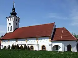 Church of Saint George | |
 Flag 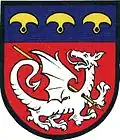 Coat of arms | |
 Kout na Šumavě Location in the Czech Republic | |
| Coordinates: 49°24′1″N 13°0′4″E / 49.40028°N 13.00111°E | |
| Country | |
| Region | Plzeň |
| District | Domažlice |
| First mentioned | 1544 |
| Area | |
• Total | 11.09 km2 (4.28 sq mi) |
| Elevation | 425 m (1,394 ft) |
| Population (2025-01-01)[1] | |
• Total | 1,076 |
| • Density | 97/km2 (250/sq mi) |
| Time zone | UTC+1 (CET) |
| • Summer (DST) | UTC+2 (CEST) |
| Postal codes | 345 02, 345 06 |
| Website | www |
Kout na Šumavě (German: Kauth) is a municipality and village in Domažlice District in the Plzeň Region of the Czech Republic. It has about 1,100 inhabitants.
Kout na Šumavě lies approximately 7 kilometres (4 mi) south-east of Domažlice, 48 km (30 mi) south-west of Plzeň, and 128 km (80 mi) south-west of Prague.
Administrative division
Kout na Šumavě consists of three municipal parts (in brackets population according to the 2021 census):[2]
- Kout na Šumavě (1,008)
- Nový Dvůr (26)
- Starý Dvůr (15)
Demographics
| Year | Pop. | ±% |
|---|---|---|
| 1869 | 1,231 | — |
| 1880 | 1,286 | +4.5% |
| 1890 | 1,231 | −4.3% |
| 1900 | 1,279 | +3.9% |
| 1910 | 1,401 | +9.5% |
| 1921 | 1,447 | +3.3% |
| 1930 | 1,421 | −1.8% |
| 1950 | 1,091 | −23.2% |
| 1961 | 1,143 | +4.8% |
| 1970 | 1,049 | −8.2% |
| 1980 | 1,119 | +6.7% |
| 1991 | 1,124 | +0.4% |
| 2001 | 1,139 | +1.3% |
| 2011 | 1,120 | −1.7% |
| 2021 | 1,049 | −6.3% |
| Source: Censuses[3][4] | ||
References
- ^ "Population of Municipalities – 1 January 2025". Czech Statistical Office. 2025-05-16.
- ^ "Public Census 2021 – basic data". Public Database (in Czech). Czech Statistical Office. 2022.
- ^ "Historický lexikon obcí České republiky 1869–2011" (in Czech). Czech Statistical Office. 2015-12-21.
- ^ "Population Census 2021: Population by sex". Public Database. Czech Statistical Office. 2021-03-27.
External links
Wikimedia Commons has media related to Kout na Šumavě.