Otov
Otov | |
|---|---|
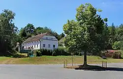 Centre of Otov | |
 Flag  Coat of arms | |
 Otov Location in the Czech Republic | |
| Coordinates: 49°29′12″N 12°50′33″E / 49.48667°N 12.84250°E | |
| Country | |
| Region | Plzeň |
| District | Domažlice |
| First mentioned | 1239 |
| Area | |
• Total | 7.11 km2 (2.75 sq mi) |
| Elevation | 412 m (1,352 ft) |
| Population (2025-01-01)[1] | |
• Total | 108 |
| • Density | 15/km2 (39/sq mi) |
| Time zone | UTC+1 (CET) |
| • Summer (DST) | UTC+2 (CEST) |
| Postal code | 345 22 |
| Website | www |
Otov (German: Wottawa) is a municipality and village in Domažlice District in the Plzeň Region of the Czech Republic. It has about 100 inhabitants.
Otov lies approximately 8 kilometres (5 mi) north-west of Domažlice, 48 km (30 mi) south-west of Plzeň, and 132 km (82 mi) south-west of Prague.
Demographics
| Year | Pop. | ±% |
|---|---|---|
| 1869 | 299 | — |
| 1880 | 309 | +3.3% |
| 1890 | 311 | +0.6% |
| 1900 | 310 | −0.3% |
| 1910 | 331 | +6.8% |
| 1921 | 350 | +5.7% |
| 1930 | 362 | +3.4% |
| 1950 | 165 | −54.4% |
| 1961 | 158 | −4.2% |
| 1970 | 106 | −32.9% |
| 1980 | 109 | +2.8% |
| 1991 | 111 | +1.8% |
| 2001 | 115 | +3.6% |
| 2011 | 85 | −26.1% |
| 2021 | 108 | +27.1% |
| Source: Censuses[2][3] | ||
References
- ^ "Population of Municipalities – 1 January 2025". Czech Statistical Office. 2025-05-16.
- ^ "Historický lexikon obcí České republiky 1869–2011" (in Czech). Czech Statistical Office. 2015-12-21.
- ^ "Population Census 2021: Population by sex". Public Database. Czech Statistical Office. 2021-03-27.
External links
Wikimedia Commons has media related to Otov.