Lachaussée
Lachaussée | |
|---|---|
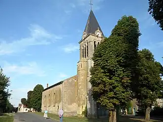 The church in Lachaussée | |
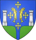 Coat of arms | |
Location of Lachaussée | |
 Lachaussée  Lachaussée | |
| Coordinates: 49°02′16″N 5°49′10″E / 49.0378°N 5.8194°E | |
| Country | France |
| Region | Grand Est |
| Department | Meuse |
| Arrondissement | Commercy |
| Canton | Saint-Mihiel |
| Intercommunality | Côtes de Meuse - Woëvre |
| Government | |
| • Mayor (2020–2026) | Didier Kopocz[1] |
Area 1 | 27.19 km2 (10.50 sq mi) |
| Population (2022)[2] | 280 |
| • Density | 10/km2 (27/sq mi) |
| Time zone | UTC+01:00 (CET) |
| • Summer (DST) | UTC+02:00 (CEST) |
| INSEE/Postal code | 55267 /55210 |
| Elevation | 203–238 m (666–781 ft) (avg. 218 m or 715 ft) |
| 1 French Land Register data, which excludes lakes, ponds, glaciers > 1 km2 (0.386 sq mi or 247 acres) and river estuaries. | |
Lachaussée (French pronunciation: [laʃose]) is a commune in the Meuse department in Grand Est in north-eastern France. In January 1973, it absorbed the former communes Haumont-lès-Lachaussée and Hadonville-lès-Lachaussée.[3]
Geography
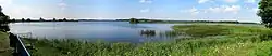
The village of Lachaussée lies on the south-eastern rim of a huge pond named Étang de Lachaussée, which was created during the Middle Ages from a marsh area and then devoted to pisciculture.
See also
References
- ^ "Répertoire national des élus: les maires" (in French). data.gouv.fr, Plateforme ouverte des données publiques françaises. 13 September 2022.
- ^ "Populations de référence 2022" (in French). The National Institute of Statistics and Economic Studies. 19 December 2024.
- ^ Modifications aux circonscriptions administratives territoriales (fusion de communes), Journal officiel de la République française n° 0290, 13 December 1972, p. 12829.
Wikimedia Commons has media related to Lachaussée.