Richecourt
Richecourt | |
|---|---|
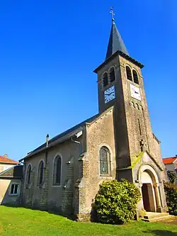 The church in Richecourt | |
 Coat of arms | |
Location of Richecourt | |
 Richecourt  Richecourt | |
| Coordinates: 48°52′50″N 5°45′43″E / 48.8806°N 5.7619°E | |
| Country | France |
| Region | Grand Est |
| Department | Meuse |
| Arrondissement | Commercy |
| Canton | Saint-Mihiel |
| Intercommunality | CC Côtes de Meuse Woëvre |
| Government | |
| • Mayor (2020–2026) | Francine Zins[1] |
Area 1 | 6.23 km2 (2.41 sq mi) |
| Population (2022)[2] | 56 |
| • Density | 9.0/km2 (23/sq mi) |
| Time zone | UTC+01:00 (CET) |
| • Summer (DST) | UTC+02:00 (CEST) |
| INSEE/Postal code | 55431 /55300 |
| Elevation | 223–243 m (732–797 ft) (avg. 239 m or 784 ft) |
| 1 French Land Register data, which excludes lakes, ponds, glaciers > 1 km2 (0.386 sq mi or 247 acres) and river estuaries. | |
Richecourt (French pronunciation: [ʁiʃkuʁ]) is a commune in the Meuse department in Grand Est in north-eastern France.
Geography
The village lies on the left bank of the Rupt de Mad, which flows northeastward through the south-eastern part of the commune.
See also
References
- ^ "Répertoire national des élus: les maires" (in French). data.gouv.fr, Plateforme ouverte des données publiques françaises. 13 September 2022.
- ^ "Populations de référence 2022" (in French). The National Institute of Statistics and Economic Studies. 19 December 2024.
Wikimedia Commons has media related to Richecourt (Meuse).