Libořice
Libořice | |
|---|---|
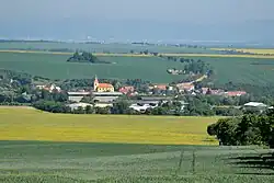 View from the south | |
 Flag  Coat of arms | |
 Libořice Location in the Czech Republic | |
| Coordinates: 50°15′17″N 13°30′55″E / 50.25472°N 13.51528°E | |
| Country | |
| Region | Ústí nad Labem |
| District | Louny |
| First mentioned | 1333 |
| Area | |
• Total | 10.33 km2 (3.99 sq mi) |
| Elevation | 259 m (850 ft) |
| Population (2025-01-01)[1] | |
• Total | 351 |
| • Density | 34/km2 (88/sq mi) |
| Time zone | UTC+1 (CET) |
| • Summer (DST) | UTC+2 (CEST) |
| Postal code | 438 01 |
| Website | www |
Libořice (German: Liboritz) is a municipality and village in Louny District in the Ústí nad Labem Region of the Czech Republic. It has about 400 inhabitants.
Libořice lies approximately 24 kilometres (15 mi) south-west of Louny, 60 km (37 mi) south-west of Ústí nad Labem, and 67 km (42 mi) west of Prague.
Administrative division
Libořice consists of two municipal parts (in brackets population according to the 2021 census):[2]
- Libořice (266)
- Železná (64)
Demographics
| Year | Pop. | ±% |
|---|---|---|
| 1869 | 1,224 | — |
| 1880 | 1,035 | −15.4% |
| 1890 | 1,027 | −0.8% |
| 1900 | 1,190 | +15.9% |
| 1910 | 1,201 | +0.9% |
| 1921 | 1,140 | −5.1% |
| 1930 | 1,077 | −5.5% |
| 1950 | 579 | −46.2% |
| 1961 | 496 | −14.3% |
| 1970 | 389 | −21.6% |
| 1980 | 376 | −3.3% |
| 1991 | 372 | −1.1% |
| 2001 | 357 | −4.0% |
| 2011 | 315 | −11.8% |
| 2021 | 330 | +4.8% |
| Source: Censuses[3][4] | ||
References
- ^ "Population of Municipalities – 1 January 2025". Czech Statistical Office. 2025-05-16.
- ^ "Public Census 2021 – basic data". Public Database (in Czech). Czech Statistical Office. 2022.
- ^ "Historický lexikon obcí České republiky 1869–2011" (in Czech). Czech Statistical Office. 2015-12-21.
- ^ "Population Census 2021: Population by sex". Public Database. Czech Statistical Office. 2021-03-27.
External links
Wikimedia Commons has media related to Libořice.