Martiel
Martiel | |
|---|---|
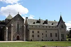
 Loc Dieu Abbey | |
Location of Martiel | |
 Martiel  Martiel | |
| Coordinates: 44°22′N 1°55′E / 44.37°N 1.92°E | |
| Country | France |
| Region | Occitania |
| Department | Aveyron |
| Arrondissement | Villefranche-de-Rouergue |
| Canton | Villeneuvois et Villefranchois |
| Government | |
| • Mayor (2020–2026) | Guy Marty[1] |
Area 1 | 46.9 km2 (18.1 sq mi) |
| Population (2022)[2] | 989 |
| • Density | 21/km2 (55/sq mi) |
| Time zone | UTC+01:00 (CET) |
| • Summer (DST) | UTC+02:00 (CEST) |
| INSEE/Postal code | 12140 /12200 |
| Elevation | 254–430 m (833–1,411 ft) (avg. 400 m or 1,300 ft) |
| 1 French Land Register data, which excludes lakes, ponds, glaciers > 1 km2 (0.386 sq mi or 247 acres) and river estuaries. | |
Martiel (French pronunciation: [maʁsjɛl]; Occitan: Marcièl) is a commune in the Aveyron department in southern France.
Population
| Year | Pop. | ±% |
|---|---|---|
| 1968 | 677 | — |
| 1975 | 635 | −6.2% |
| 1982 | 706 | +11.2% |
| 1990 | 798 | +13.0% |
| 1999 | 823 | +3.1% |
| 2008 | 903 | +9.7% |
See also
References
- ^ "Répertoire national des élus: les maires". data.gouv.fr, Plateforme ouverte des données publiques françaises (in French). 2 December 2020.
- ^ "Populations de référence 2022" (in French). The National Institute of Statistics and Economic Studies. 19 December 2024.
Wikimedia Commons has media related to Martiel.