Žalhostice
Žalhostice | |
|---|---|
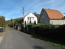 A street in Žalhostice | |
 Flag  Coat of arms | |
 Žalhostice Location in the Czech Republic | |
| Coordinates: 50°31′23″N 14°5′29″E / 50.52306°N 14.09139°E | |
| Country | |
| Region | Ústí nad Labem |
| District | Litoměřice |
| First mentioned | 1319 |
| Area | |
• Total | 2.33 km2 (0.90 sq mi) |
| Elevation | 151 m (495 ft) |
| Population (2025-01-01)[1] | |
• Total | 584 |
| • Density | 250/km2 (650/sq mi) |
| Time zone | UTC+1 (CET) |
| • Summer (DST) | UTC+2 (CEST) |
| Postal code | 411 01 |
| Website | www |
Žalhostice (German: Czalositz, Tschalositz) is a municipality and village in Litoměřice District in the Ústí nad Labem Region of the Czech Republic. It has about 600 inhabitants.
Žalhostice lies approximately 3 kilometres (2 mi) west of Litoměřice, 15 km (9 mi) south of Ústí nad Labem, and 55 km (34 mi) north-west of Prague.
Demographics
| Year | Pop. | ±% |
|---|---|---|
| 1869 | 247 | — |
| 1880 | 298 | +20.6% |
| 1890 | 332 | +11.4% |
| 1900 | 502 | +51.2% |
| 1910 | 719 | +43.2% |
| 1921 | 861 | +19.7% |
| 1930 | 928 | +7.8% |
| 1950 | 709 | −23.6% |
| 1961 | 752 | +6.1% |
| 1970 | 685 | −8.9% |
| 1980 | 557 | −18.7% |
| 1991 | 487 | −12.6% |
| 2001 | 474 | −2.7% |
| 2011 | 527 | +11.2% |
| 2021 | 505 | −4.2% |
| Source: Censuses[2][3] | ||
References
- ^ "Population of Municipalities – 1 January 2025". Czech Statistical Office. 2025-05-16.
- ^ "Historický lexikon obcí České republiky 1869–2011" (in Czech). Czech Statistical Office. 2015-12-21.
- ^ "Population Census 2021: Population by sex". Public Database. Czech Statistical Office. 2021-03-27.
External links
Wikimedia Commons has media related to Žalhostice.